You are here: Home > Network List > TA - USArray Transportable Network (new EarthScope stations) Stations List
> Station G03D McMinnville, OR, USA > Earthquake Result Viewer
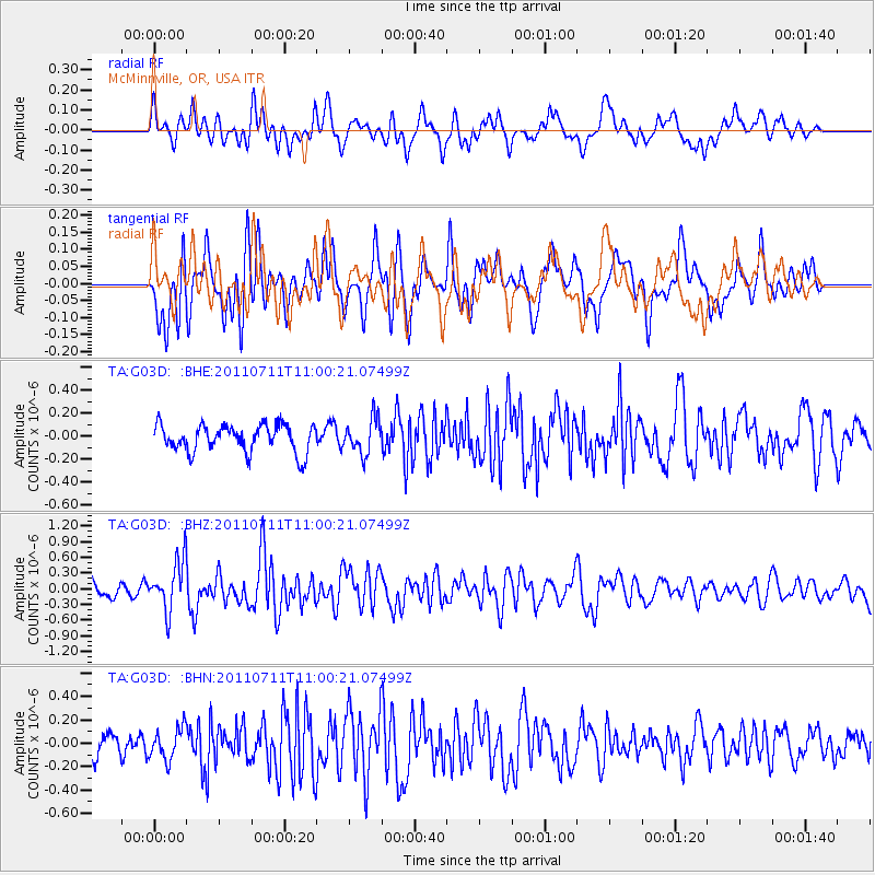
G03D McMinnville, OR, USA - Earthquake Result Viewer
*The percent match for this event was below the threshold and hence no stack was calculated.
| Earthquake location: |
Tonga Islands Region |
| Earthquake latitude/longitude: |
-22.7/-174.7 |
| Earthquake time(UTC): |
2011/07/11 (192) 10:48:32 GMT |
| Earthquake Depth: |
21 km |
| Earthquake Magnitude: |
5.6 MB, 5.4 MS, 5.6 MW, 5.6 MW |
| Earthquake Catalog/Contributor: |
WHDF/NEIC |
|
| Network: |
TA USArray Transportable Network (new EarthScope stations) |
| Station: |
G03D McMinnville, OR, USA |
| Lat/Lon: |
45.21 N/123.26 W |
| Elevation: |
222 m |
|
| Distance: |
82.2 deg |
| Az: |
33.932 deg |
| Baz: |
226.831 deg |
| Ray Param: |
$rayparam |
*The percent match for this event was below the threshold and hence was not used in the summary stack. |
|
| Radial Match: |
60.85973 % |
| Radial Bump: |
400 |
| Transverse Match: |
68.35676 % |
| Transverse Bump: |
400 |
| SOD ConfigId: |
395004 |
| Insert Time: |
2011-12-16 08:39:50.041 +0000 |
| GWidth: |
2.5 |
| Max Bumps: |
400 |
| Tol: |
0.001 |
|
Signal To Noise
| Channel | StoN | STA | LTA |
| TA:G03D: :BHZ:20110711T11:00:21.07499Z | 3.4102006 | 4.760686E-7 | 1.3960135E-7 |
| TA:G03D: :BHN:20110711T11:00:21.07499Z | 1.0014513 | 1.3479283E-7 | 1.3459749E-7 |
| TA:G03D: :BHE:20110711T11:00:21.07499Z | 1.2752297 | 1.5096836E-7 | 1.1838523E-7 |
| Arrivals |
| Ps | |
| PpPs | |
| PsPs/PpSs | |


