You are here: Home > Network List > TA - USArray Transportable Network (new EarthScope stations) Stations List
> Station L02D Cave Junction, OR, USA > Earthquake Result Viewer
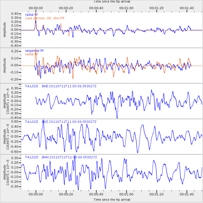
L02D Cave Junction, OR, USA - Earthquake Result Viewer
*The percent match for this event was below the threshold and hence no stack was calculated.
| Earthquake location: |
Tonga Islands Region |
| Earthquake latitude/longitude: |
-22.7/-174.7 |
| Earthquake time(UTC): |
2011/07/11 (192) 10:48:32 GMT |
| Earthquake Depth: |
21 km |
| Earthquake Magnitude: |
5.6 MB, 5.4 MS, 5.6 MW, 5.6 MW |
| Earthquake Catalog/Contributor: |
WHDF/NEIC |
|
| Network: |
TA USArray Transportable Network (new EarthScope stations) |
| Station: |
L02D Cave Junction, OR, USA |
| Lat/Lon: |
42.16 N/123.60 W |
| Elevation: |
458 m |
|
| Distance: |
80.0 deg |
| Az: |
36.017 deg |
| Baz: |
226.921 deg |
| Ray Param: |
$rayparam |
*The percent match for this event was below the threshold and hence was not used in the summary stack. |
|
| Radial Match: |
62.567932 % |
| Radial Bump: |
400 |
| Transverse Match: |
30.380686 % |
| Transverse Bump: |
400 |
| SOD ConfigId: |
395004 |
| Insert Time: |
2011-12-16 08:41:14.319 +0000 |
| GWidth: |
2.5 |
| Max Bumps: |
400 |
| Tol: |
0.001 |
|
Signal To Noise
| Channel | StoN | STA | LTA |
| TA:L02D: :BHZ:20110711T11:00:09.050027Z | 3.464823 | 2.4030675E-7 | 6.935614E-8 |
| TA:L02D: :BHN:20110711T11:00:09.050027Z | 1.3769681 | 1.0559357E-7 | 7.668556E-8 |
| TA:L02D: :BHE:20110711T11:00:09.050027Z | 0.97476935 | 7.2373034E-8 | 7.4246316E-8 |
| Arrivals |
| Ps | |
| PpPs | |
| PsPs/PpSs | |


