You are here: Home > Network List > UW - Pacific Northwest Regional Seismic Network Stations List
> Station FISH Seaside, OR, USA > Earthquake Result Viewer
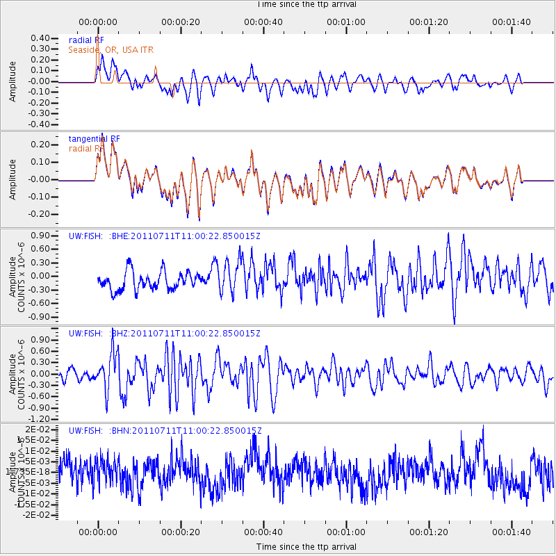
FISH Seaside, OR, USA - Earthquake Result Viewer
*The percent match for this event was below the threshold and hence no stack was calculated.
| Earthquake location: |
Tonga Islands Region |
| Earthquake latitude/longitude: |
-22.7/-174.7 |
| Earthquake time(UTC): |
2011/07/11 (192) 10:48:32 GMT |
| Earthquake Depth: |
21 km |
| Earthquake Magnitude: |
5.6 MB, 5.4 MS, 5.6 MW, 5.6 MW |
| Earthquake Catalog/Contributor: |
WHDF/NEIC |
|
| Network: |
UW Pacific Northwest Regional Seismic Network |
| Station: |
FISH Seaside, OR, USA |
| Lat/Lon: |
45.93 N/123.56 W |
| Elevation: |
325 m |
|
| Distance: |
82.6 deg |
| Az: |
33.26 deg |
| Baz: |
226.532 deg |
| Ray Param: |
$rayparam |
*The percent match for this event was below the threshold and hence was not used in the summary stack. |
|
| Radial Match: |
55.247345 % |
| Radial Bump: |
400 |
| Transverse Match: |
54.844013 % |
| Transverse Bump: |
400 |
| SOD ConfigId: |
395004 |
| Insert Time: |
2011-12-16 08:54:04.423 +0000 |
| GWidth: |
2.5 |
| Max Bumps: |
400 |
| Tol: |
0.001 |
|
Signal To Noise
| Channel | StoN | STA | LTA |
| UW:FISH: :BHZ:20110711T11:00:22.850015Z | 4.637047 | 4.966649E-7 | 1.07108015E-7 |
| UW:FISH: :BHN:20110711T11:00:22.850015Z | 0.9204029 | 5.2854383E-9 | 5.7425273E-9 |
| UW:FISH: :BHE:20110711T11:00:22.850015Z | 1.8472421 | 3.6723475E-7 | 1.9880164E-7 |
| Arrivals |
| Ps | |
| PpPs | |
| PsPs/PpSs | |


