You are here: Home > Network List > UW - Pacific Northwest Regional Seismic Network Stations List
> Station LEBA Lebam, WA, USA > Earthquake Result Viewer
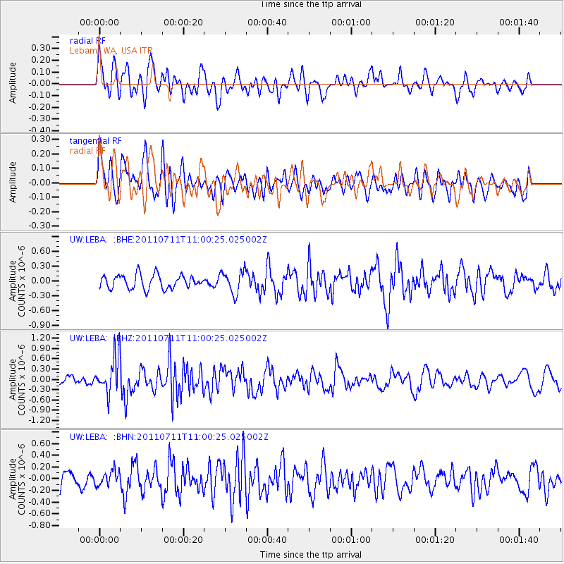
LEBA Lebam, WA, USA - Earthquake Result Viewer
*The percent match for this event was below the threshold and hence no stack was calculated.
| Earthquake location: |
Tonga Islands Region |
| Earthquake latitude/longitude: |
-22.7/-174.7 |
| Earthquake time(UTC): |
2011/07/11 (192) 10:48:32 GMT |
| Earthquake Depth: |
21 km |
| Earthquake Magnitude: |
5.6 MB, 5.4 MS, 5.6 MW, 5.6 MW |
| Earthquake Catalog/Contributor: |
WHDF/NEIC |
|
| Network: |
UW Pacific Northwest Regional Seismic Network |
| Station: |
LEBA Lebam, WA, USA |
| Lat/Lon: |
46.55 N/123.56 W |
| Elevation: |
73 m |
|
| Distance: |
83.0 deg |
| Az: |
32.808 deg |
| Baz: |
226.473 deg |
| Ray Param: |
$rayparam |
*The percent match for this event was below the threshold and hence was not used in the summary stack. |
|
| Radial Match: |
73.8311 % |
| Radial Bump: |
400 |
| Transverse Match: |
58.296993 % |
| Transverse Bump: |
400 |
| SOD ConfigId: |
395004 |
| Insert Time: |
2011-12-16 08:54:56.508 +0000 |
| GWidth: |
2.5 |
| Max Bumps: |
400 |
| Tol: |
0.001 |
|
Signal To Noise
| Channel | StoN | STA | LTA |
| UW:LEBA: :BHZ:20110711T11:00:25.025002Z | 4.700633 | 5.59287E-7 | 1.1898121E-7 |
| UW:LEBA: :BHN:20110711T11:00:25.025002Z | 1.3131111 | 1.2776152E-7 | 9.7296805E-8 |
| UW:LEBA: :BHE:20110711T11:00:25.025002Z | 1.6636783 | 2.3287211E-7 | 1.3997423E-7 |
| Arrivals |
| Ps | |
| PpPs | |
| PsPs/PpSs | |


