You are here: Home > Network List > PS - Pacific21 Stations List
> Station PATS 6onpei, Micronesia > Earthquake Result Viewer
PATS 6onpei, Micronesia - Earthquake Result Viewer

| Earthquake location: |
Negros, Philippines |
| Earthquake latitude/longitude: |
9.5/122.2 |
| Earthquake time(UTC): |
2011/07/11 (192) 20:47:04 GMT |
| Earthquake Depth: |
19 km |
| Earthquake Magnitude: |
6.1 MB, 6.1 MS, 6.4 MW, 6.2 MW |
| Earthquake Catalog/Contributor: |
WHDF/NEIC |
|
| Network: |
PS Pacific21 |
| Station: |
PATS 6onpei, Micronesia |
| Lat/Lon: |
6.84 N/158.32 E |
| Elevation: |
10 m |
|
| Distance: |
35.9 deg |
| Az: |
91.464 deg |
| Baz: |
276.742 deg |
| Ray Param: |
0.07697303 |
| Estimated Moho Depth: |
10.0 km |
| Estimated Crust Vp/Vs: |
1.73 |
| Assumed Crust Vp: |
4.24 km/s |
| Estimated Crust Vs: |
2.454 km/s |
| Estimated Crust Poisson's Ratio: |
0.25 |
|
| Radial Match: |
91.18757 % |
| Radial Bump: |
400 |
| Transverse Match: |
75.24183 % |
| Transverse Bump: |
366 |
| SOD ConfigId: |
395004 |
| Insert Time: |
2011-12-16 09:21:57.502 +0000 |
| GWidth: |
2.5 |
| Max Bumps: |
400 |
| Tol: |
0.001 |
|
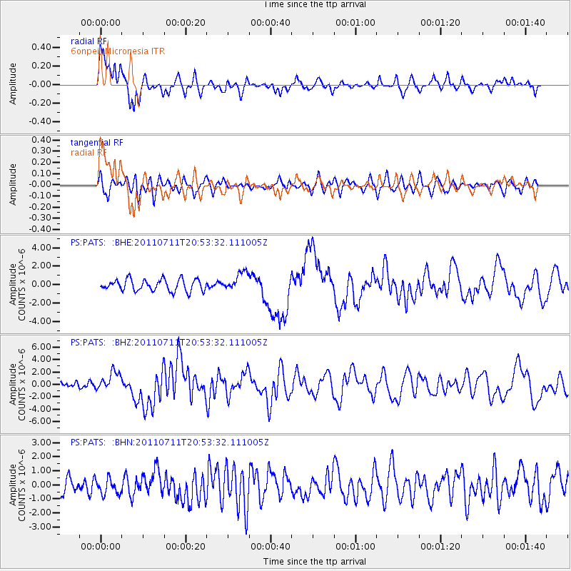
Signal To Noise
| Channel | StoN | STA | LTA |
| PS:PATS: :BHZ:20110711T20:53:32.111005Z | 2.631355 | 1.5491734E-6 | 5.88736E-7 |
| PS:PATS: :BHN:20110711T20:53:32.111005Z | 0.65301675 | 5.4831577E-7 | 8.396657E-7 |
| PS:PATS: :BHE:20110711T20:53:32.111005Z | 1.655621 | 1.050357E-6 | 6.3441877E-7 |
| Arrivals |
| Ps | 1.8 SECOND |
| PpPs | 6.2 SECOND |
| PsPs/PpSs | 8.0 SECOND |


