You are here: Home > Network List > TA - USArray Transportable Network (new EarthScope stations) Stations List
> Station O48A Farmland, IN, USA > Earthquake Result Viewer
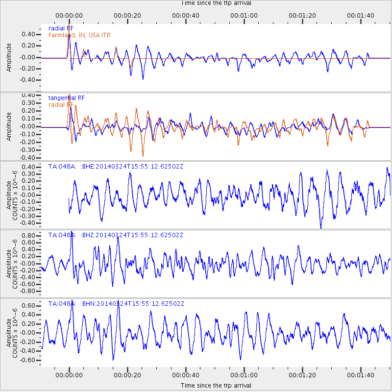
O48A Farmland, IN, USA - Earthquake Result Viewer
*The percent match for this event was below the threshold and hence no stack was calculated.
| Earthquake location: |
Near Coast Of Northern Chile |
| Earthquake latitude/longitude: |
-19.6/-70.8 |
| Earthquake time(UTC): |
2014/03/24 (083) 15:45:31 GMT |
| Earthquake Depth: |
18 km |
| Earthquake Magnitude: |
5.6 MWB, 5.5 MWR, 5.7 MWC, 5.7 MWW |
| Earthquake Catalog/Contributor: |
NEIC PDE/NEIC COMCAT |
|
| Network: |
TA USArray Transportable Network (new EarthScope stations) |
| Station: |
O48A Farmland, IN, USA |
| Lat/Lon: |
40.26 N/85.16 W |
| Elevation: |
300 m |
|
| Distance: |
61.0 deg |
| Az: |
347.489 deg |
| Baz: |
164.523 deg |
| Ray Param: |
$rayparam |
*The percent match for this event was below the threshold and hence was not used in the summary stack. |
|
| Radial Match: |
64.351654 % |
| Radial Bump: |
400 |
| Transverse Match: |
61.81528 % |
| Transverse Bump: |
400 |
| SOD ConfigId: |
3390531 |
| Insert Time: |
2019-04-10 21:30:07.489 +0000 |
| GWidth: |
2.5 |
| Max Bumps: |
400 |
| Tol: |
0.001 |
|
Signal To Noise
| Channel | StoN | STA | LTA |
| TA:O48A: :BHZ:20140324T15:55:12.62502Z | 2.2619338 | 3.445846E-7 | 1.523407E-7 |
| TA:O48A: :BHN:20140324T15:55:12.62502Z | 1.5356637 | 3.2017428E-7 | 2.0849245E-7 |
| TA:O48A: :BHE:20140324T15:55:12.62502Z | 0.8162586 | 1.1922704E-7 | 1.4606529E-7 |
| Arrivals |
| Ps | |
| PpPs | |
| PsPs/PpSs | |


