You are here: Home > Network List > G - GEOSCOPE Stations List
> Station CAN Canberra, Australia > Earthquake Result Viewer
CAN Canberra, Australia - Earthquake Result Viewer
| Earthquake location: |
Mindoro, Philippines |
| Earthquake latitude/longitude: |
13.5/121.1 |
| Earthquake time(UTC): |
1994/11/14 (318) 19:15:30 GMT |
| Earthquake Depth: |
33 km |
| Earthquake Magnitude: |
6.1 MB, 7.1 MS, 7.1 UNKNOWN, 7.1 MW |
| Earthquake Catalog/Contributor: |
WHDF/NEIC |
|
| Network: |
G GEOSCOPE |
| Station: |
CAN Canberra, Australia |
| Lat/Lon: |
35.32 S/149.00 E |
| Elevation: |
650 m |
|
| Distance: |
55.3 deg |
| Az: |
152.257 deg |
| Baz: |
326.383 deg |
| Ray Param: |
0.064810485 |
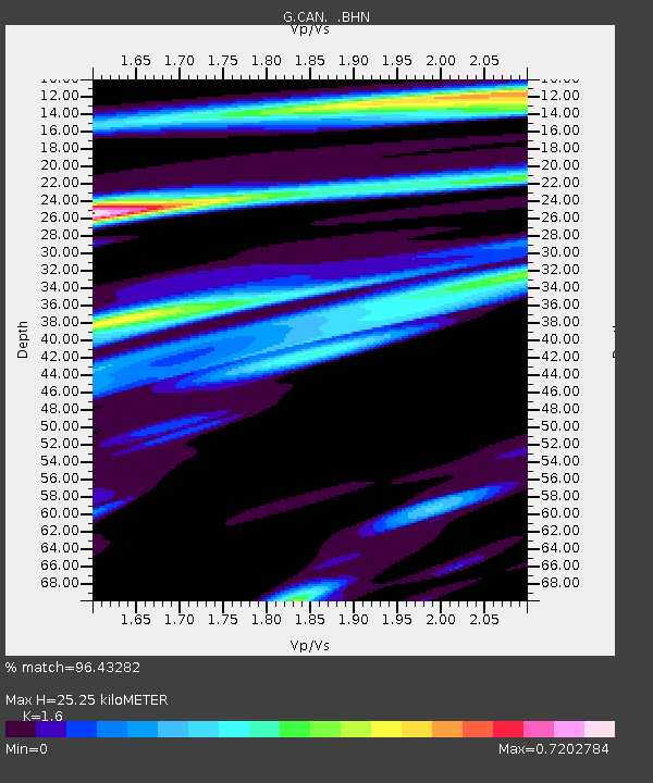
| Estimated Moho Depth: |
25.25 km |
| Estimated Crust Vp/Vs: |
1.60 |
| Assumed Crust Vp: |
6.633 km/s |
| Estimated Crust Vs: |
4.146 km/s |
| Estimated Crust Poisson's Ratio: |
0.18 |
|
| Radial Match: |
96.43282 % |
| Radial Bump: |
355 |
| Transverse Match: |
86.924126 % |
| Transverse Bump: |
400 |
| SOD ConfigId: |
16938 |
| Insert Time: |
2010-02-26 21:39:51.515 +0000 |
| GWidth: |
2.5 |
| Max Bumps: |
400 |
| Tol: |
0.001 |
|
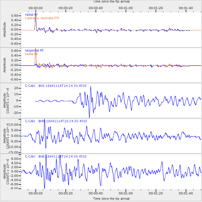
Signal To Noise
| Channel | StoN | STA | LTA |
| G:CAN: :BHN:19941114T19:24:30.450Z | 9.370434 | 3.7613238E-6 | 4.0140338E-7 |
| G:CAN: :BHE:19941114T19:24:30.450Z | 4.050047 | 2.0920756E-6 | 5.165559E-7 |
| G:CAN: :BHZ:19941114T19:24:30.450Z | 9.521502 | 7.717188E-6 | 8.105012E-7 |
| Arrivals |
| Ps | 2.4 SECOND |
| PpPs | 9.3 SECOND |
| PsPs/PpSs | 12 SECOND |


