You are here: Home > Network List > TA - USArray Transportable Network (new EarthScope stations) Stations List
> Station J33A Davis, SD, USA > Earthquake Result Viewer
J33A Davis, SD, USA - Earthquake Result Viewer
| Earthquake location: |
Near Coast Of Central Chile |
| Earthquake latitude/longitude: |
-33.8/-71.8 |
| Earthquake time(UTC): |
2011/07/16 (197) 00:26:12 GMT |
| Earthquake Depth: |
20 km |
| Earthquake Magnitude: |
5.8 MB, 5.8 MS, 6.1 MW, 6.0 MW |
| Earthquake Catalog/Contributor: |
WHDF/NEIC |
|
| Network: |
TA USArray Transportable Network (new EarthScope stations) |
| Station: |
J33A Davis, SD, USA |
| Lat/Lon: |
43.32 N/96.97 W |
| Elevation: |
400 m |
|
| Distance: |
80.1 deg |
| Az: |
341.66 deg |
| Baz: |
158.966 deg |
| Ray Param: |
0.048467007 |
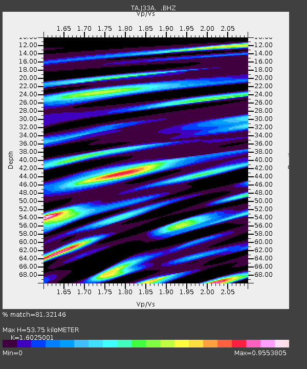
| Estimated Moho Depth: |
53.75 km |
| Estimated Crust Vp/Vs: |
1.60 |
| Assumed Crust Vp: |
6.498 km/s |
| Estimated Crust Vs: |
4.055 km/s |
| Estimated Crust Poisson's Ratio: |
0.18 |
|
| Radial Match: |
81.32146 % |
| Radial Bump: |
400 |
| Transverse Match: |
52.792473 % |
| Transverse Bump: |
400 |
| SOD ConfigId: |
401841 |
| Insert Time: |
2011-12-21 00:52:27.156 +0000 |
| GWidth: |
2.5 |
| Max Bumps: |
400 |
| Tol: |
0.001 |
|

Signal To Noise
| Channel | StoN | STA | LTA |
| TA:J33A: :BHZ:20110716T00:37:49.850022Z | 3.6709929 | 4.327863E-7 | 1.17893535E-7 |
| TA:J33A: :BHN:20110716T00:37:49.850022Z | 3.6172304 | 3.5852605E-7 | 9.911618E-8 |
| TA:J33A: :BHE:20110716T00:37:49.850022Z | 1.9426544 | 2.1496335E-7 | 1.10654454E-7 |
| Arrivals |
| Ps | 5.1 SECOND |
| PpPs | 21 SECOND |
| PsPs/PpSs | 26 SECOND |


