You are here: Home > Network List > G - GEOSCOPE Stations List
> Station CAN Canberra, Australia > Earthquake Result Viewer
CAN Canberra, Australia - Earthquake Result Viewer

| Earthquake location: |
Samar, Philippines |
| Earthquake latitude/longitude: |
12.6/125.3 |
| Earthquake time(UTC): |
1995/05/05 (125) 03:53:47 GMT |
| Earthquake Depth: |
33 km |
| Earthquake Magnitude: |
6.2 MB, 7.0 MS, 7.1 UNKNOWN, 7.0 MW |
| Earthquake Catalog/Contributor: |
WHDF/NEIC |
|
| Network: |
G GEOSCOPE |
| Station: |
CAN Canberra, Australia |
| Lat/Lon: |
35.32 S/149.00 E |
| Elevation: |
650 m |
|
| Distance: |
52.7 deg |
| Az: |
155.608 deg |
| Baz: |
330.464 deg |
| Ray Param: |
0.066533595 |
| Estimated Moho Depth: |
11.75 km |
| Estimated Crust Vp/Vs: |
2.10 |
| Assumed Crust Vp: |
6.633 km/s |
| Estimated Crust Vs: |
3.162 km/s |
| Estimated Crust Poisson's Ratio: |
0.35 |
|
| Radial Match: |
94.636696 % |
| Radial Bump: |
316 |
| Transverse Match: |
84.45796 % |
| Transverse Bump: |
400 |
| SOD ConfigId: |
6273 |
| Insert Time: |
2010-02-26 21:40:29.345 +0000 |
| GWidth: |
2.5 |
| Max Bumps: |
400 |
| Tol: |
0.001 |
|
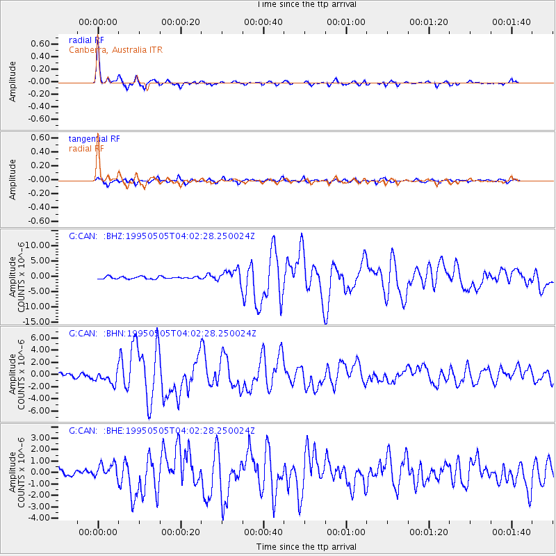
Signal To Noise
| Channel | StoN | STA | LTA |
| G:CAN: :BHN:19950505T04:02:28.250024Z | 2.7976084 | 1.0437956E-6 | 3.731028E-7 |
| G:CAN: :BHE:19950505T04:02:28.250024Z | 1.8078046 | 6.467355E-7 | 3.5774633E-7 |
| G:CAN: :BHZ:19950505T04:02:28.250024Z | 5.9747705 | 2.2275526E-6 | 3.7282646E-7 |
| Arrivals |
| Ps | 2.0 SECOND |
| PpPs | 5.2 SECOND |
| PsPs/PpSs | 7.3 SECOND |


