You are here: Home > Network List > TA - USArray Transportable Network (new EarthScope stations) Stations List
> Station H31A Wolsey, SD, USA > Earthquake Result Viewer
H31A Wolsey, SD, USA - Earthquake Result Viewer
| Earthquake location: |
Near Coast Of Central Chile |
| Earthquake latitude/longitude: |
-33.8/-71.8 |
| Earthquake time(UTC): |
2011/07/16 (197) 00:26:12 GMT |
| Earthquake Depth: |
20 km |
| Earthquake Magnitude: |
5.8 MB, 5.8 MS, 6.1 MW, 6.0 MW |
| Earthquake Catalog/Contributor: |
WHDF/NEIC |
|
| Network: |
TA USArray Transportable Network (new EarthScope stations) |
| Station: |
H31A Wolsey, SD, USA |
| Lat/Lon: |
44.48 N/98.48 W |
| Elevation: |
415 m |
|
| Distance: |
81.6 deg |
| Az: |
341.065 deg |
| Baz: |
157.828 deg |
| Ray Param: |
0.047444846 |
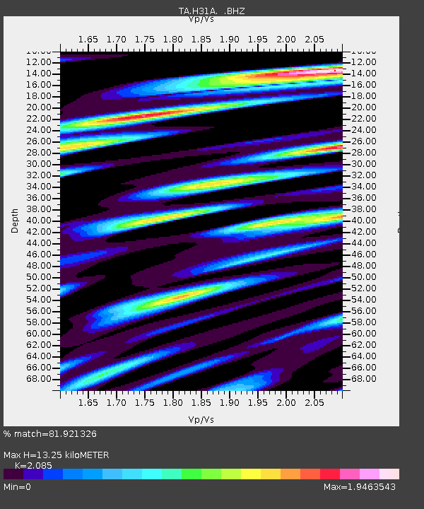
| Estimated Moho Depth: |
13.25 km |
| Estimated Crust Vp/Vs: |
2.09 |
| Assumed Crust Vp: |
6.53 km/s |
| Estimated Crust Vs: |
3.132 km/s |
| Estimated Crust Poisson's Ratio: |
0.35 |
|
| Radial Match: |
81.921326 % |
| Radial Bump: |
400 |
| Transverse Match: |
67.247185 % |
| Transverse Bump: |
400 |
| SOD ConfigId: |
401841 |
| Insert Time: |
2011-12-21 00:54:26.392 +0000 |
| GWidth: |
2.5 |
| Max Bumps: |
400 |
| Tol: |
0.001 |
|

Signal To Noise
| Channel | StoN | STA | LTA |
| TA:H31A: :BHZ:20110716T00:37:57.725022Z | 4.990614 | 6.2646313E-7 | 1.2552827E-7 |
| TA:H31A: :BHN:20110716T00:37:57.725022Z | 2.130593 | 4.139277E-7 | 1.9427816E-7 |
| TA:H31A: :BHE:20110716T00:37:57.725022Z | 1.6790549 | 2.1337053E-7 | 1.2707775E-7 |
| Arrivals |
| Ps | 2.3 SECOND |
| PpPs | 6.1 SECOND |
| PsPs/PpSs | 8.4 SECOND |


