You are here: Home > Network List > IU - Global Seismograph Network (GSN - IRIS/USGS) Stations List
> Station XMAS Kiritimati Island, Republic of Kiribati > Earthquake Result Viewer
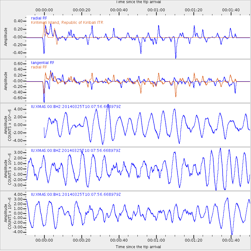
XMAS Kiritimati Island, Republic of Kiribati - Earthquake Result Viewer
*The percent match for this event was below the threshold and hence no stack was calculated.
| Earthquake location: |
Near Coast Of Ecuador |
| Earthquake latitude/longitude: |
-2.2/-79.3 |
| Earthquake time(UTC): |
2014/03/25 (084) 09:56:28 GMT |
| Earthquake Depth: |
10 km |
| Earthquake Magnitude: |
5.2 MW |
| Earthquake Catalog/Contributor: |
ISC/ISC |
|
| Network: |
IU Global Seismograph Network (GSN - IRIS/USGS) |
| Station: |
XMAS Kiritimati Island, Republic of Kiribati |
| Lat/Lon: |
2.04 N/157.45 W |
| Elevation: |
20 m |
|
| Distance: |
78.3 deg |
| Az: |
272.537 deg |
| Baz: |
92.689 deg |
| Ray Param: |
$rayparam |
*The percent match for this event was below the threshold and hence was not used in the summary stack. |
|
| Radial Match: |
48.631016 % |
| Radial Bump: |
400 |
| Transverse Match: |
72.1684 % |
| Transverse Bump: |
400 |
| SOD ConfigId: |
3390531 |
| Insert Time: |
2019-04-10 21:40:03.166 +0000 |
| GWidth: |
2.5 |
| Max Bumps: |
400 |
| Tol: |
0.001 |
|
Signal To Noise
| Channel | StoN | STA | LTA |
| IU:XMAS:00:BHZ:20140325T10:07:56.668979Z | 0.8793843 | 1.5577631E-6 | 1.7714246E-6 |
| IU:XMAS:00:BH1:20140325T10:07:56.668979Z | 1.3220794 | 2.0166956E-6 | 1.5253966E-6 |
| IU:XMAS:00:BH2:20140325T10:07:56.668979Z | 2.01363 | 3.35306E-6 | 1.6651818E-6 |
| Arrivals |
| Ps | |
| PpPs | |
| PsPs/PpSs | |


