You are here: Home > Network List > TA - USArray Transportable Network (new EarthScope stations) Stations List
> Station W41B Gary Mavity, Velonia, AR, USA > Earthquake Result Viewer
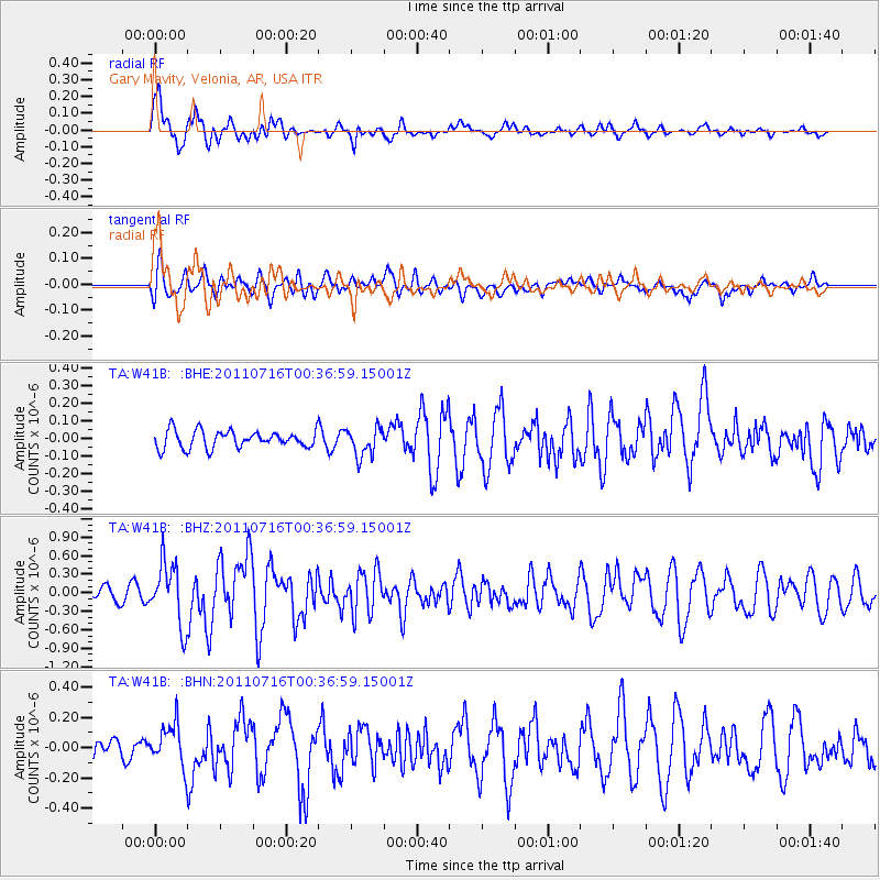
W41B Gary Mavity, Velonia, AR, USA - Earthquake Result Viewer
*The percent match for this event was below the threshold and hence no stack was calculated.
| Earthquake location: |
Near Coast Of Central Chile |
| Earthquake latitude/longitude: |
-33.8/-71.8 |
| Earthquake time(UTC): |
2011/07/16 (197) 00:26:12 GMT |
| Earthquake Depth: |
20 km |
| Earthquake Magnitude: |
5.8 MB, 5.8 MS, 6.1 MW, 6.0 MW |
| Earthquake Catalog/Contributor: |
WHDF/NEIC |
|
| Network: |
TA USArray Transportable Network (new EarthScope stations) |
| Station: |
W41B Gary Mavity, Velonia, AR, USA |
| Lat/Lon: |
35.17 N/92.25 W |
| Elevation: |
95 m |
|
| Distance: |
71.2 deg |
| Az: |
342.435 deg |
| Baz: |
162.14 deg |
| Ray Param: |
$rayparam |
*The percent match for this event was below the threshold and hence was not used in the summary stack. |
|
| Radial Match: |
79.46452 % |
| Radial Bump: |
400 |
| Transverse Match: |
56.122143 % |
| Transverse Bump: |
400 |
| SOD ConfigId: |
401841 |
| Insert Time: |
2011-12-21 01:05:27.987 +0000 |
| GWidth: |
2.5 |
| Max Bumps: |
400 |
| Tol: |
0.001 |
|
Signal To Noise
| Channel | StoN | STA | LTA |
| TA:W41B: :BHZ:20110716T00:36:59.15001Z | 4.376933 | 4.9734837E-7 | 1.1362942E-7 |
| TA:W41B: :BHN:20110716T00:36:59.15001Z | 1.6867584 | 1.3727471E-7 | 8.138374E-8 |
| TA:W41B: :BHE:20110716T00:36:59.15001Z | 1.6484891 | 8.100586E-8 | 4.913946E-8 |
| Arrivals |
| Ps | |
| PpPs | |
| PsPs/PpSs | |


