You are here: Home > Network List > TA - USArray Transportable Network (new EarthScope stations) Stations List
> Station X44A Crenshaw, MS, USA > Earthquake Result Viewer
X44A Crenshaw, MS, USA - Earthquake Result Viewer
| Earthquake location: |
Near Coast Of Central Chile |
| Earthquake latitude/longitude: |
-33.8/-71.8 |
| Earthquake time(UTC): |
2011/07/16 (197) 00:26:12 GMT |
| Earthquake Depth: |
20 km |
| Earthquake Magnitude: |
5.8 MB, 5.8 MS, 6.1 MW, 6.0 MW |
| Earthquake Catalog/Contributor: |
WHDF/NEIC |
|
| Network: |
TA USArray Transportable Network (new EarthScope stations) |
| Station: |
X44A Crenshaw, MS, USA |
| Lat/Lon: |
34.50 N/90.15 W |
| Elevation: |
109 m |
|
| Distance: |
70.1 deg |
| Az: |
343.978 deg |
| Baz: |
163.846 deg |
| Ray Param: |
0.055187687 |
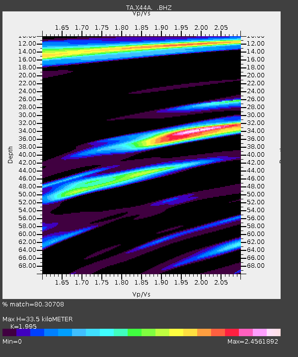
| Estimated Moho Depth: |
33.5 km |
| Estimated Crust Vp/Vs: |
2.00 |
| Assumed Crust Vp: |
6.273 km/s |
| Estimated Crust Vs: |
3.144 km/s |
| Estimated Crust Poisson's Ratio: |
0.33 |
|
| Radial Match: |
80.30708 % |
| Radial Bump: |
384 |
| Transverse Match: |
54.198174 % |
| Transverse Bump: |
291 |
| SOD ConfigId: |
401841 |
| Insert Time: |
2011-12-21 01:07:12.296 +0000 |
| GWidth: |
2.5 |
| Max Bumps: |
400 |
| Tol: |
0.001 |
|

Signal To Noise
| Channel | StoN | STA | LTA |
| TA:X44A: :BHZ:20110716T00:36:52.174973Z | 4.432528 | 6.4542934E-7 | 1.4561202E-7 |
| TA:X44A: :BHN:20110716T00:36:52.174973Z | 0.34532782 | 1.653364E-7 | 4.7878103E-7 |
| TA:X44A: :BHE:20110716T00:36:52.174973Z | 0.9325513 | 7.654879E-7 | 8.208534E-7 |
| Arrivals |
| Ps | 5.5 SECOND |
| PpPs | 16 SECOND |
| PsPs/PpSs | 21 SECOND |


