You are here: Home > Network List > AR - Northern Arizona Network Stations List
> Station U15A North Rim, AZ, USA > Earthquake Result Viewer
U15A North Rim, AZ, USA - Earthquake Result Viewer
| Earthquake location: |
Tonga Islands Region |
| Earthquake latitude/longitude: |
-22.4/-175.0 |
| Earthquake time(UTC): |
2011/07/16 (197) 07:03:32 GMT |
| Earthquake Depth: |
7.0 km |
| Earthquake Magnitude: |
5.7 MB, 5.6 MS, 5.8 MW, 5.7 MW |
| Earthquake Catalog/Contributor: |
WHDF/NEIC |
|
| Network: |
AR Northern Arizona Network |
| Station: |
U15A North Rim, AZ, USA |
| Lat/Lon: |
36.43 N/112.29 W |
| Elevation: |
2489 m |
|
| Distance: |
83.2 deg |
| Az: |
46.199 deg |
| Baz: |
235.893 deg |
| Ray Param: |
0.046339028 |
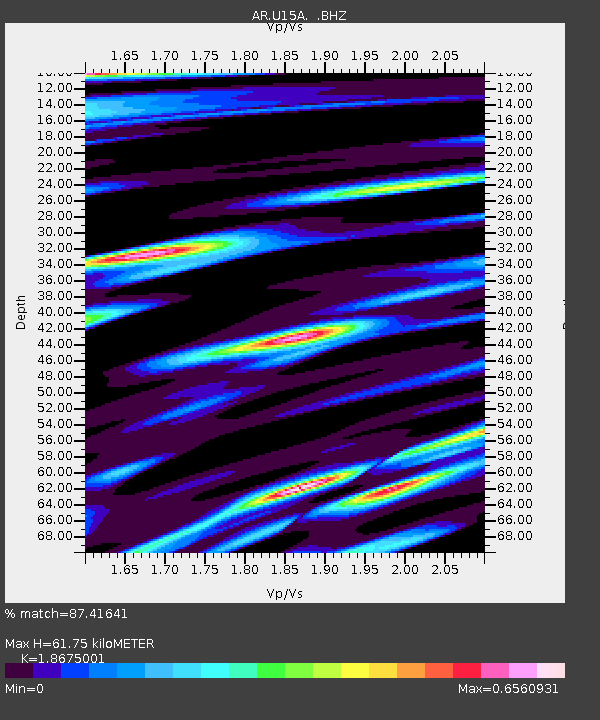
| Estimated Moho Depth: |
61.75 km |
| Estimated Crust Vp/Vs: |
1.87 |
| Assumed Crust Vp: |
6.194 km/s |
| Estimated Crust Vs: |
3.317 km/s |
| Estimated Crust Poisson's Ratio: |
0.30 |
|
| Radial Match: |
87.41641 % |
| Radial Bump: |
394 |
| Transverse Match: |
83.16629 % |
| Transverse Bump: |
400 |
| SOD ConfigId: |
401841 |
| Insert Time: |
2011-12-21 01:16:25.674 +0000 |
| GWidth: |
2.5 |
| Max Bumps: |
400 |
| Tol: |
0.001 |
|

Signal To Noise
| Channel | StoN | STA | LTA |
| AR:U15A: :BHZ:20110716T07:15:28.274983Z | 7.4463897 | 4.2807116E-7 | 5.7487075E-8 |
| AR:U15A: :BHN:20110716T07:15:28.274983Z | 1.3091501 | 7.297615E-8 | 5.5743147E-8 |
| AR:U15A: :BHE:20110716T07:15:28.274983Z | 1.8751181 | 1.01652006E-7 | 5.4210986E-8 |
| Arrivals |
| Ps | 8.8 SECOND |
| PpPs | 28 SECOND |
| PsPs/PpSs | 37 SECOND |


