You are here: Home > Network List > AZ - ANZA Regional Network Stations List
> Station SMER AZ.SMER > Earthquake Result Viewer
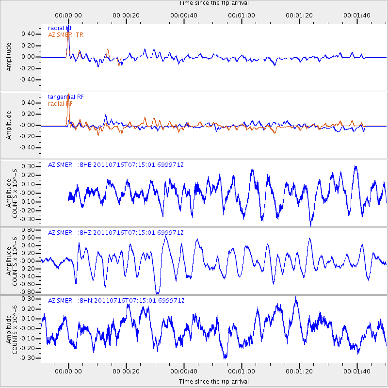
SMER AZ.SMER - Earthquake Result Viewer
*The percent match for this event was below the threshold and hence no stack was calculated.
| Earthquake location: |
Tonga Islands Region |
| Earthquake latitude/longitude: |
-22.4/-175.0 |
| Earthquake time(UTC): |
2011/07/16 (197) 07:03:32 GMT |
| Earthquake Depth: |
7.0 km |
| Earthquake Magnitude: |
5.7 MB, 5.6 MS, 5.8 MW, 5.7 MW |
| Earthquake Catalog/Contributor: |
WHDF/NEIC |
|
| Network: |
AZ ANZA Regional Network |
| Station: |
SMER AZ.SMER |
| Lat/Lon: |
33.46 N/117.17 W |
| Elevation: |
355 m |
|
| Distance: |
78.3 deg |
| Az: |
46.284 deg |
| Baz: |
233.123 deg |
| Ray Param: |
$rayparam |
*The percent match for this event was below the threshold and hence was not used in the summary stack. |
|
| Radial Match: |
66.49368 % |
| Radial Bump: |
400 |
| Transverse Match: |
41.159096 % |
| Transverse Bump: |
400 |
| SOD ConfigId: |
401841 |
| Insert Time: |
2011-12-21 01:20:02.297 +0000 |
| GWidth: |
2.5 |
| Max Bumps: |
400 |
| Tol: |
0.001 |
|
Signal To Noise
| Channel | StoN | STA | LTA |
| AZ:SMER: :BHZ:20110716T07:15:01.699971Z | 2.6225543 | 2.463993E-7 | 9.395394E-8 |
| AZ:SMER: :BHN:20110716T07:15:01.699971Z | 1.399842 | 1.6251983E-7 | 1.160987E-7 |
| AZ:SMER: :BHE:20110716T07:15:01.699971Z | 1.5041523 | 1.03550484E-7 | 6.884308E-8 |
| Arrivals |
| Ps | |
| PpPs | |
| PsPs/PpSs | |


