You are here: Home > Network List > CI - Caltech Regional Seismic Network Stations List
> Station SMM Simmler, CA, USA > Earthquake Result Viewer
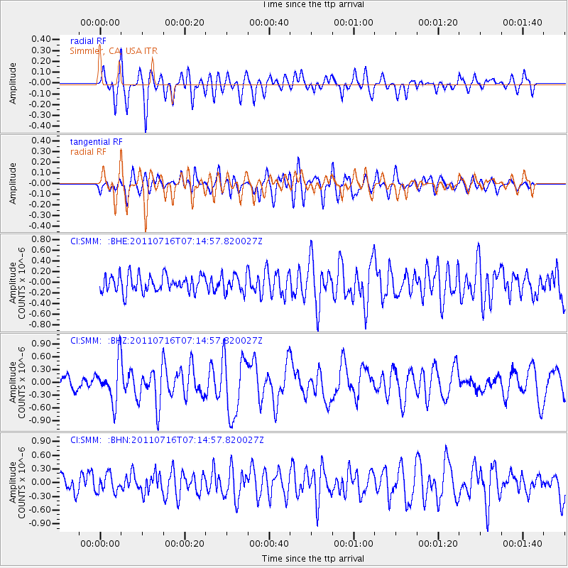
SMM Simmler, CA, USA - Earthquake Result Viewer
*The percent match for this event was below the threshold and hence no stack was calculated.
| Earthquake location: |
Tonga Islands Region |
| Earthquake latitude/longitude: |
-22.4/-175.0 |
| Earthquake time(UTC): |
2011/07/16 (197) 07:03:32 GMT |
| Earthquake Depth: |
7.0 km |
| Earthquake Magnitude: |
5.7 MB, 5.6 MS, 5.8 MW, 5.7 MW |
| Earthquake Catalog/Contributor: |
WHDF/NEIC |
|
| Network: |
CI Caltech Regional Seismic Network |
| Station: |
SMM Simmler, CA, USA |
| Lat/Lon: |
35.31 N/120.00 W |
| Elevation: |
599 m |
|
| Distance: |
77.5 deg |
| Az: |
43.321 deg |
| Baz: |
230.913 deg |
| Ray Param: |
$rayparam |
*The percent match for this event was below the threshold and hence was not used in the summary stack. |
|
| Radial Match: |
76.6371 % |
| Radial Bump: |
400 |
| Transverse Match: |
65.28715 % |
| Transverse Bump: |
400 |
| SOD ConfigId: |
401841 |
| Insert Time: |
2011-12-21 01:23:00.087 +0000 |
| GWidth: |
2.5 |
| Max Bumps: |
400 |
| Tol: |
0.001 |
|
Signal To Noise
| Channel | StoN | STA | LTA |
| CI:SMM: :BHZ:20110716T07:14:57.820027Z | 3.9761705 | 4.719992E-7 | 1.1870697E-7 |
| CI:SMM: :BHN:20110716T07:14:57.820027Z | 1.2977444 | 1.9092171E-7 | 1.4711812E-7 |
| CI:SMM: :BHE:20110716T07:14:57.820027Z | 1.0912234 | 1.6759951E-7 | 1.5358863E-7 |
| Arrivals |
| Ps | |
| PpPs | |
| PsPs/PpSs | |


