You are here: Home > Network List > G - GEOSCOPE Stations List
> Station CAN Canberra, Australia > Earthquake Result Viewer
CAN Canberra, Australia - Earthquake Result Viewer

| Earthquake location: |
South Of Fiji Islands |
| Earthquake latitude/longitude: |
-24.1/-177.0 |
| Earthquake time(UTC): |
1996/04/16 (107) 00:30:54 GMT |
| Earthquake Depth: |
111 km |
| Earthquake Magnitude: |
6.4 MB, 6.8 MS, 7.1 UNKNOWN, 7.1 MW |
| Earthquake Catalog/Contributor: |
WHDF/NEIC |
|
| Network: |
G GEOSCOPE |
| Station: |
CAN Canberra, Australia |
| Lat/Lon: |
35.32 S/149.00 E |
| Elevation: |
650 m |
|
| Distance: |
31.4 deg |
| Az: |
241.199 deg |
| Baz: |
78.4 deg |
| Ray Param: |
0.07878324 |
| Estimated Moho Depth: |
45.75 km |
| Estimated Crust Vp/Vs: |
1.67 |
| Assumed Crust Vp: |
6.633 km/s |
| Estimated Crust Vs: |
3.978 km/s |
| Estimated Crust Poisson's Ratio: |
0.22 |
|
| Radial Match: |
94.7034 % |
| Radial Bump: |
311 |
| Transverse Match: |
68.56207 % |
| Transverse Bump: |
400 |
| SOD ConfigId: |
6273 |
| Insert Time: |
2010-02-26 21:41:11.997 +0000 |
| GWidth: |
2.5 |
| Max Bumps: |
400 |
| Tol: |
0.001 |
|
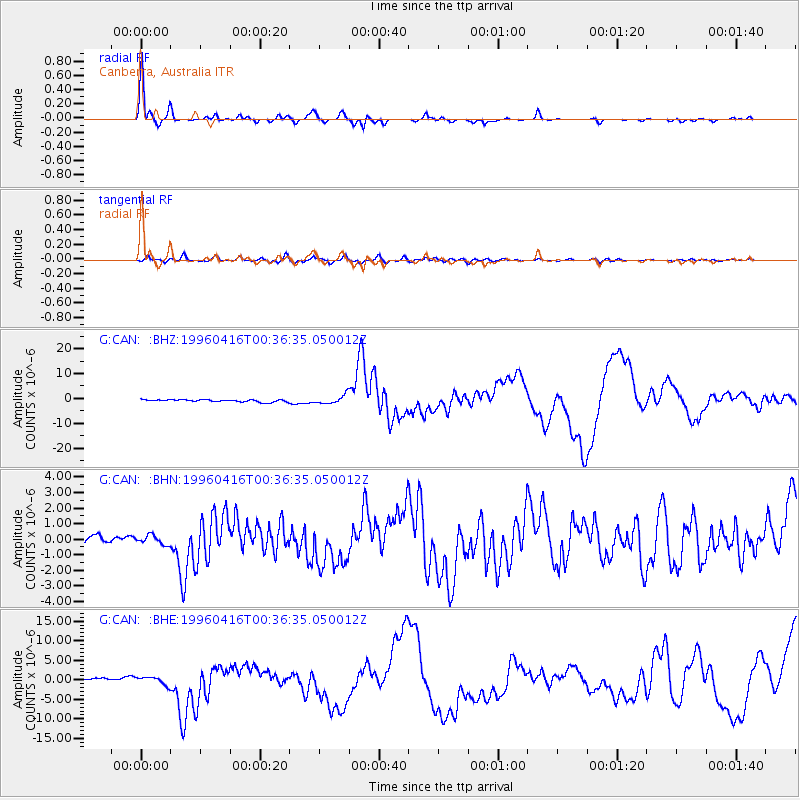
Signal To Noise
| Channel | StoN | STA | LTA |
| G:CAN: :BHN:19960416T00:36:35.050012Z | 1.2834792 | 2.8998056E-7 | 2.2593319E-7 |
| G:CAN: :BHE:19960416T00:36:35.050012Z | 3.1213205 | 1.011304E-6 | 3.2399876E-7 |
| G:CAN: :BHZ:19960416T00:36:35.050012Z | 3.6654248 | 1.6963307E-6 | 4.6279243E-7 |
| Arrivals |
| Ps | 5.0 SECOND |
| PpPs | 17 SECOND |
| PsPs/PpSs | 22 SECOND |


