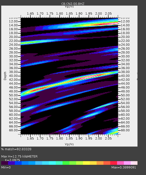
CN2 Changchun,Jilin Province - Earthquake Result Viewer

Earthquake location: South Of Fiji Islands
Earthquake latitude/longitude: -26.1/179.3
Earthquake time(UTC): 2014/03/26 (085) 03:29:36 GMT
Earthquake Depth: 493 km
Earthquake Magnitude: 6.5 MWP, 6.3 MWW, 6.3 MWC, 6.4 MWB, 6.4 MWC, 6.5 MI
Earthquake Catalog/Contributor: NEIC PDE/NEIC COMCAT
Network: CB China National Seismic Network
Station: CN2 Changchun,Jilin Province
Lat/Lon: 43.48 N/125.26 E
Elevation: 223 m
Distance: 85.1 deg
Az: 323.761 deg
Baz: 133.088 deg
Ray Param: 0.04360569
Estimated Moho Depth: 12.75 km
Estimated Crust Vp/Vs: 2.10
Assumed Crust Vp: 6.459 km/s
Estimated Crust Vs: 3.08 km/s
Estimated Crust Poisson's Ratio: 0.35
Radial Match: 92.83328 %
Radial Bump: 351
Transverse Match: 77.618256 %
Transverse Bump: 400
SOD ConfigId: 3390531
Insert Time: 2019-04-10 21:46:25.570 +0000
GWidth: 2.5
Max Bumps: 400
Tol: 0.001

Signal To Noise

ChannelStoNSTALTA
CB:CN2:00:BHZ:20140326T03:40:48.22999Z40.85433.6624351E-68.964626E-8
CB:CN2:00:BHN:20140326T03:40:48.22999Z9.7785085.8616564E-75.9944284E-8
CB:CN2:00:BHE:20140326T03:40:48.22999Z10.9432257.3916976E-76.7545884E-8
Arrivals
Ps2.2 SECOND
PpPs6.0 SECOND
PsPs/PpSs8.2 SECOND