You are here: Home > Network List > IW - Intermountain West Stations List
> Station MOOW Moose Ponds, Wyoming, USA > Earthquake Result Viewer
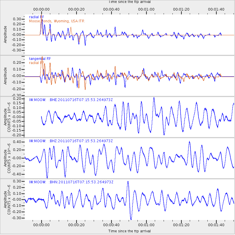
MOOW Moose Ponds, Wyoming, USA - Earthquake Result Viewer
*The percent match for this event was below the threshold and hence no stack was calculated.
| Earthquake location: |
Tonga Islands Region |
| Earthquake latitude/longitude: |
-22.4/-175.0 |
| Earthquake time(UTC): |
2011/07/16 (197) 07:03:32 GMT |
| Earthquake Depth: |
7.0 km |
| Earthquake Magnitude: |
5.7 MB, 5.6 MS, 5.8 MW, 5.7 MW |
| Earthquake Catalog/Contributor: |
WHDF/NEIC |
|
| Network: |
IW Intermountain West |
| Station: |
MOOW Moose Ponds, Wyoming, USA |
| Lat/Lon: |
43.75 N/110.74 W |
| Elevation: |
2128 m |
|
| Distance: |
88.3 deg |
| Az: |
40.772 deg |
| Baz: |
236.486 deg |
| Ray Param: |
$rayparam |
*The percent match for this event was below the threshold and hence was not used in the summary stack. |
|
| Radial Match: |
74.70102 % |
| Radial Bump: |
297 |
| Transverse Match: |
67.33094 % |
| Transverse Bump: |
314 |
| SOD ConfigId: |
401841 |
| Insert Time: |
2011-12-21 01:26:19.577 +0000 |
| GWidth: |
2.5 |
| Max Bumps: |
400 |
| Tol: |
0.001 |
|
Signal To Noise
| Channel | StoN | STA | LTA |
| IW:MOOW: :BHZ:20110716T07:15:53.264973Z | 3.95166 | 2.217877E-7 | 5.61252E-8 |
| IW:MOOW: :BHN:20110716T07:15:53.264973Z | 2.0619884 | 7.4909025E-8 | 3.632854E-8 |
| IW:MOOW: :BHE:20110716T07:15:53.264973Z | 0.86042637 | 3.3231146E-8 | 3.862172E-8 |
| Arrivals |
| Ps | |
| PpPs | |
| PsPs/PpSs | |


