You are here: Home > Network List > IW - Intermountain West Stations List
> Station DLMT Dillon, Montana, USA > Earthquake Result Viewer
DLMT Dillon, Montana, USA - Earthquake Result Viewer
*The percent match for this event was below the threshold and hence no stack was calculated.
| Earthquake location: |
Tonga Islands Region |
| Earthquake latitude/longitude: |
-22.4/-175.0 |
| Earthquake time(UTC): |
2011/07/16 (197) 07:03:32 GMT |
| Earthquake Depth: |
7.0 km |
| Earthquake Magnitude: |
5.7 MB, 5.6 MS, 5.8 MW, 5.7 MW |
| Earthquake Catalog/Contributor: |
WHDF/NEIC |
|
| Network: |
IW Intermountain West |
| Station: |
DLMT Dillon, Montana, USA |
| Lat/Lon: |
45.36 N/112.60 W |
| Elevation: |
1569 m |
|
| Distance: |
88.1 deg |
| Az: |
38.692 deg |
| Baz: |
235.126 deg |
| Ray Param: |
$rayparam |
*The percent match for this event was below the threshold and hence was not used in the summary stack. |
|
| Radial Match: |
59.791187 % |
| Radial Bump: |
392 |
| Transverse Match: |
71.90618 % |
| Transverse Bump: |
400 |
| SOD ConfigId: |
401841 |
| Insert Time: |
2011-12-21 01:26:48.523 +0000 |
| GWidth: |
2.5 |
| Max Bumps: |
400 |
| Tol: |
0.001 |
|
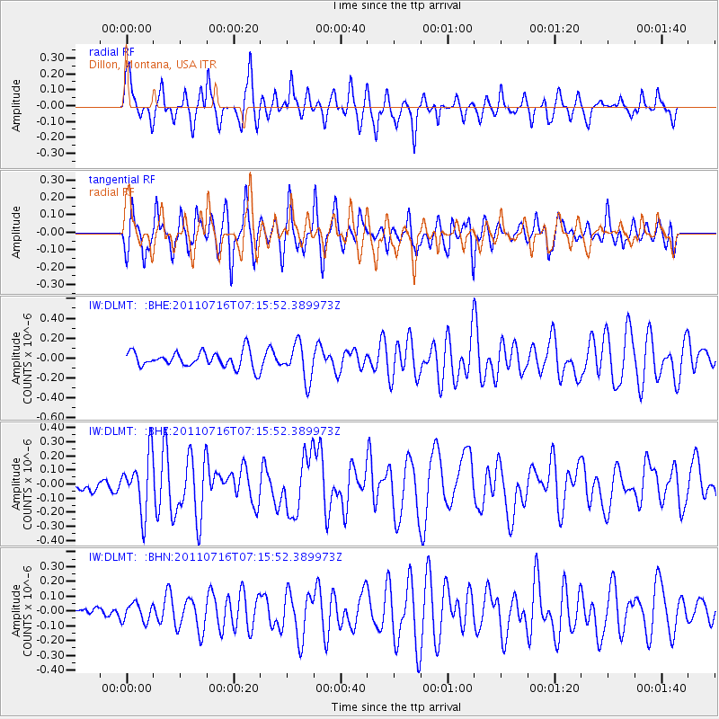
Signal To Noise
| Channel | StoN | STA | LTA |
| IW:DLMT: :BHZ:20110716T07:15:52.389973Z | 4.776335 | 2.0085984E-7 | 4.2053138E-8 |
| IW:DLMT: :BHN:20110716T07:15:52.389973Z | 0.84927446 | 6.050331E-8 | 7.1241175E-8 |
| IW:DLMT: :BHE:20110716T07:15:52.389973Z | 2.278519 | 1.8241633E-7 | 8.0059166E-8 |
| Arrivals |
| Ps | |
| PpPs | |
| PsPs/PpSs | |


