You are here: Home > Network List > TA - USArray Transportable Network (new EarthScope stations) Stations List
> Station F30A Leola, SD, USA > Earthquake Result Viewer
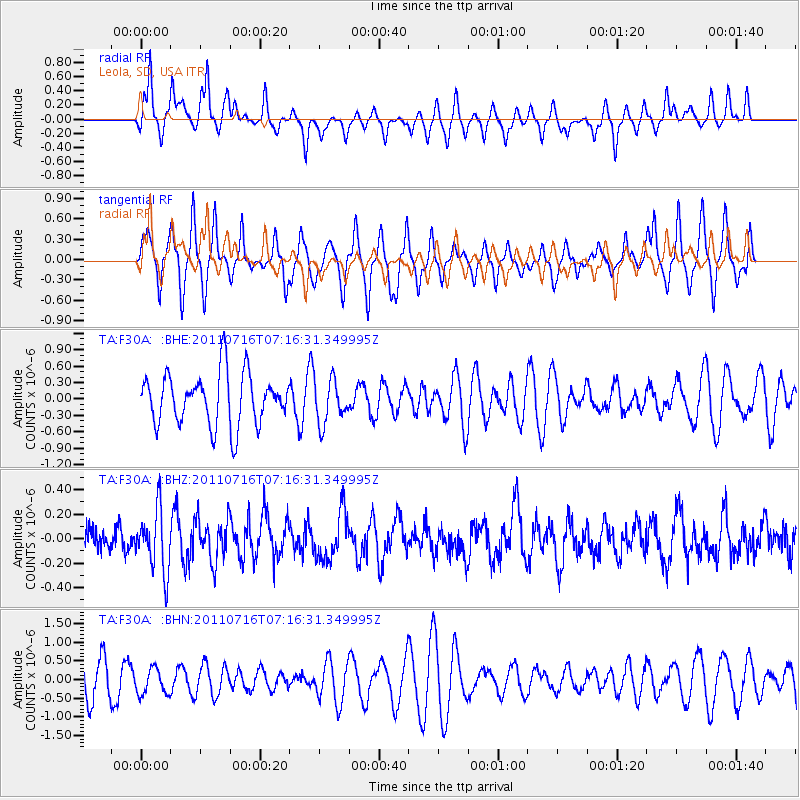
F30A Leola, SD, USA - Earthquake Result Viewer
*The percent match for this event was below the threshold and hence no stack was calculated.
| Earthquake location: |
Tonga Islands Region |
| Earthquake latitude/longitude: |
-22.4/-175.0 |
| Earthquake time(UTC): |
2011/07/16 (197) 07:03:32 GMT |
| Earthquake Depth: |
7.0 km |
| Earthquake Magnitude: |
5.7 MB, 5.6 MS, 5.8 MW, 5.7 MW |
| Earthquake Catalog/Contributor: |
WHDF/NEIC |
|
| Network: |
TA USArray Transportable Network (new EarthScope stations) |
| Station: |
F30A Leola, SD, USA |
| Lat/Lon: |
45.84 N/99.03 W |
| Elevation: |
601 m |
|
| Distance: |
96.6 deg |
| Az: |
43.061 deg |
| Baz: |
244.633 deg |
| Ray Param: |
$rayparam |
*The percent match for this event was below the threshold and hence was not used in the summary stack. |
|
| Radial Match: |
56.26957 % |
| Radial Bump: |
238 |
| Transverse Match: |
54.008614 % |
| Transverse Bump: |
289 |
| SOD ConfigId: |
401841 |
| Insert Time: |
2011-12-21 01:29:42.564 +0000 |
| GWidth: |
2.5 |
| Max Bumps: |
400 |
| Tol: |
0.001 |
|
Signal To Noise
| Channel | StoN | STA | LTA |
| TA:F30A: :BHZ:20110716T07:16:31.349995Z | 2.6657698 | 2.5172903E-7 | 9.4430156E-8 |
| TA:F30A: :BHN:20110716T07:16:31.349995Z | 0.65353745 | 3.4877593E-7 | 5.336739E-7 |
| TA:F30A: :BHE:20110716T07:16:31.349995Z | 0.8460168 | 3.9753238E-7 | 4.6988706E-7 |
| Arrivals |
| Ps | |
| PpPs | |
| PsPs/PpSs | |


