You are here: Home > Network List > TA - USArray Transportable Network (new EarthScope stations) Stations List
> Station G03D McMinnville, OR, USA > Earthquake Result Viewer
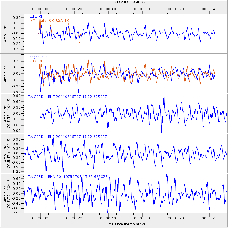
G03D McMinnville, OR, USA - Earthquake Result Viewer
*The percent match for this event was below the threshold and hence no stack was calculated.
| Earthquake location: |
Tonga Islands Region |
| Earthquake latitude/longitude: |
-22.4/-175.0 |
| Earthquake time(UTC): |
2011/07/16 (197) 07:03:32 GMT |
| Earthquake Depth: |
7.0 km |
| Earthquake Magnitude: |
5.7 MB, 5.6 MS, 5.8 MW, 5.7 MW |
| Earthquake Catalog/Contributor: |
WHDF/NEIC |
|
| Network: |
TA USArray Transportable Network (new EarthScope stations) |
| Station: |
G03D McMinnville, OR, USA |
| Lat/Lon: |
45.21 N/123.26 W |
| Elevation: |
222 m |
|
| Distance: |
82.1 deg |
| Az: |
34.074 deg |
| Baz: |
227.166 deg |
| Ray Param: |
$rayparam |
*The percent match for this event was below the threshold and hence was not used in the summary stack. |
|
| Radial Match: |
55.248524 % |
| Radial Bump: |
400 |
| Transverse Match: |
65.8297 % |
| Transverse Bump: |
363 |
| SOD ConfigId: |
401841 |
| Insert Time: |
2011-12-21 01:30:42.009 +0000 |
| GWidth: |
2.5 |
| Max Bumps: |
400 |
| Tol: |
0.001 |
|
Signal To Noise
| Channel | StoN | STA | LTA |
| TA:G03D: :BHZ:20110716T07:15:22.62502Z | 2.5405636 | 4.888741E-7 | 1.9242741E-7 |
| TA:G03D: :BHN:20110716T07:15:22.62502Z | 0.626361 | 1.3182301E-7 | 2.1045854E-7 |
| TA:G03D: :BHE:20110716T07:15:22.62502Z | 1.0628352 | 2.265204E-7 | 2.1312843E-7 |
| Arrivals |
| Ps | |
| PpPs | |
| PsPs/PpSs | |


