You are here: Home > Network List > TA - USArray Transportable Network (new EarthScope stations) Stations List
> Station 534A Blanco, TX, USA > Earthquake Result Viewer
534A Blanco, TX, USA - Earthquake Result Viewer
| Earthquake location: |
Tonga Islands Region |
| Earthquake latitude/longitude: |
-22.4/-175.0 |
| Earthquake time(UTC): |
2011/07/16 (197) 07:03:32 GMT |
| Earthquake Depth: |
7.0 km |
| Earthquake Magnitude: |
5.7 MB, 5.6 MS, 5.8 MW, 5.7 MW |
| Earthquake Catalog/Contributor: |
WHDF/NEIC |
|
| Network: |
TA USArray Transportable Network (new EarthScope stations) |
| Station: |
534A Blanco, TX, USA |
| Lat/Lon: |
30.03 N/98.48 W |
| Elevation: |
461 m |
|
| Distance: |
90.1 deg |
| Az: |
57.496 deg |
| Baz: |
244.125 deg |
| Ray Param: |
0.041697126 |
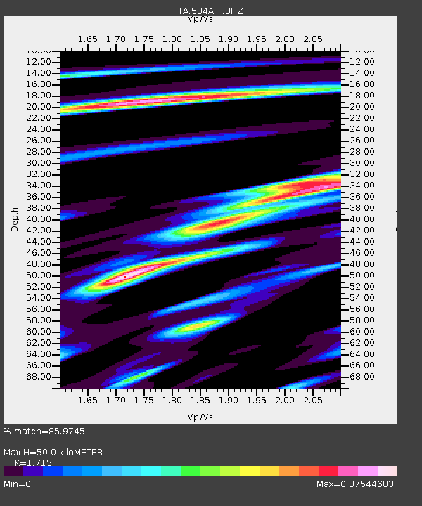
| Estimated Moho Depth: |
50.0 km |
| Estimated Crust Vp/Vs: |
1.72 |
| Assumed Crust Vp: |
6.498 km/s |
| Estimated Crust Vs: |
3.789 km/s |
| Estimated Crust Poisson's Ratio: |
0.24 |
|
| Radial Match: |
85.9745 % |
| Radial Bump: |
302 |
| Transverse Match: |
64.43217 % |
| Transverse Bump: |
400 |
| SOD ConfigId: |
401841 |
| Insert Time: |
2011-12-21 01:31:30.004 +0000 |
| GWidth: |
2.5 |
| Max Bumps: |
400 |
| Tol: |
0.001 |
|
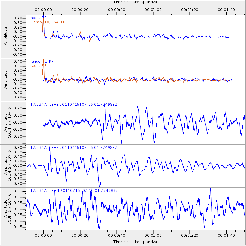
Signal To Noise
| Channel | StoN | STA | LTA |
| TA:534A: :BHZ:20110716T07:16:01.774983Z | 11.637036 | 3.3466864E-7 | 2.8758924E-8 |
| TA:534A: :BHN:20110716T07:16:01.774983Z | 1.1474183 | 4.6125677E-8 | 4.0199534E-8 |
| TA:534A: :BHE:20110716T07:16:01.774983Z | 4.240867 | 1.2094017E-7 | 2.8517793E-8 |
| Arrivals |
| Ps | 5.6 SECOND |
| PpPs | 20 SECOND |
| PsPs/PpSs | 26 SECOND |


