You are here: Home > Network List > TA - USArray Transportable Network (new EarthScope stations) Stations List
> Station 238A Jacksonville, TX, USA > Earthquake Result Viewer
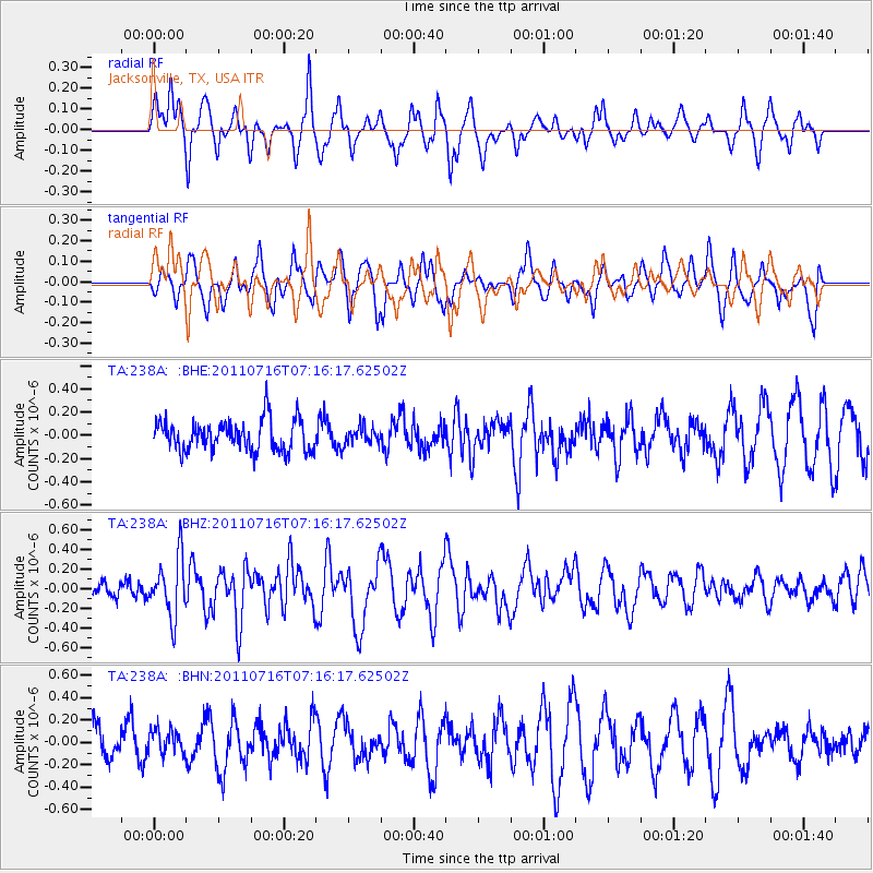
238A Jacksonville, TX, USA - Earthquake Result Viewer
*The percent match for this event was below the threshold and hence no stack was calculated.
| Earthquake location: |
Tonga Islands Region |
| Earthquake latitude/longitude: |
-22.4/-175.0 |
| Earthquake time(UTC): |
2011/07/16 (197) 07:03:32 GMT |
| Earthquake Depth: |
7.0 km |
| Earthquake Magnitude: |
5.7 MB, 5.6 MS, 5.8 MW, 5.7 MW |
| Earthquake Catalog/Contributor: |
WHDF/NEIC |
|
| Network: |
TA USArray Transportable Network (new EarthScope stations) |
| Station: |
238A Jacksonville, TX, USA |
| Lat/Lon: |
32.00 N/95.12 W |
| Elevation: |
126 m |
|
| Distance: |
93.6 deg |
| Az: |
56.93 deg |
| Baz: |
245.864 deg |
| Ray Param: |
$rayparam |
*The percent match for this event was below the threshold and hence was not used in the summary stack. |
|
| Radial Match: |
56.64801 % |
| Radial Bump: |
349 |
| Transverse Match: |
49.579575 % |
| Transverse Bump: |
384 |
| SOD ConfigId: |
401841 |
| Insert Time: |
2011-12-21 01:35:12.604 +0000 |
| GWidth: |
2.5 |
| Max Bumps: |
400 |
| Tol: |
0.001 |
|
Signal To Noise
| Channel | StoN | STA | LTA |
| TA:238A: :BHZ:20110716T07:16:17.62502Z | 2.7555609 | 2.9682644E-7 | 1.0771906E-7 |
| TA:238A: :BHN:20110716T07:16:17.62502Z | 0.48460397 | 1.05350395E-7 | 2.1739483E-7 |
| TA:238A: :BHE:20110716T07:16:17.62502Z | 0.56892896 | 7.502647E-8 | 1.3187318E-7 |
| Arrivals |
| Ps | |
| PpPs | |
| PsPs/PpSs | |


