You are here: Home > Network List > TA - USArray Transportable Network (new EarthScope stations) Stations List
> Station 136A Ennis, TX, USA > Earthquake Result Viewer
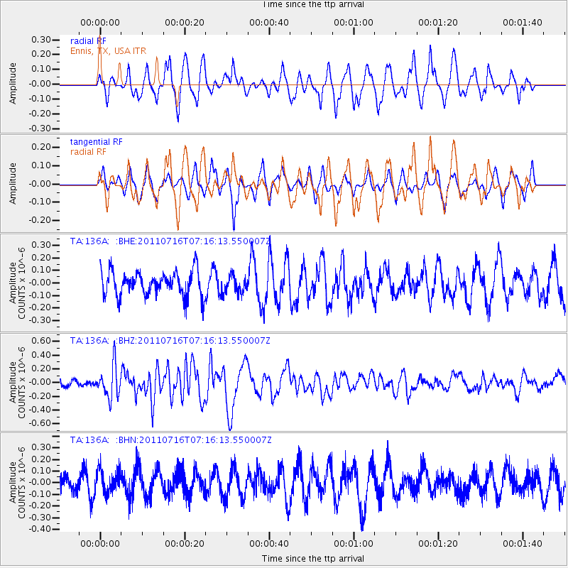
136A Ennis, TX, USA - Earthquake Result Viewer
*The percent match for this event was below the threshold and hence no stack was calculated.
| Earthquake location: |
Tonga Islands Region |
| Earthquake latitude/longitude: |
-22.4/-175.0 |
| Earthquake time(UTC): |
2011/07/16 (197) 07:03:32 GMT |
| Earthquake Depth: |
7.0 km |
| Earthquake Magnitude: |
5.7 MB, 5.6 MS, 5.8 MW, 5.7 MW |
| Earthquake Catalog/Contributor: |
WHDF/NEIC |
|
| Network: |
TA USArray Transportable Network (new EarthScope stations) |
| Station: |
136A Ennis, TX, USA |
| Lat/Lon: |
32.47 N/96.53 W |
| Elevation: |
113 m |
|
| Distance: |
92.7 deg |
| Az: |
56.006 deg |
| Baz: |
245.166 deg |
| Ray Param: |
$rayparam |
*The percent match for this event was below the threshold and hence was not used in the summary stack. |
|
| Radial Match: |
50.76547 % |
| Radial Bump: |
400 |
| Transverse Match: |
57.1297 % |
| Transverse Bump: |
400 |
| SOD ConfigId: |
401841 |
| Insert Time: |
2011-12-21 01:37:15.752 +0000 |
| GWidth: |
2.5 |
| Max Bumps: |
400 |
| Tol: |
0.001 |
|
Signal To Noise
| Channel | StoN | STA | LTA |
| TA:136A: :BHZ:20110716T07:16:13.550007Z | 3.69252 | 2.3745065E-7 | 6.430586E-8 |
| TA:136A: :BHN:20110716T07:16:13.550007Z | 1.2466902 | 1.0166955E-7 | 8.1551576E-8 |
| TA:136A: :BHE:20110716T07:16:13.550007Z | 0.68414885 | 6.7388356E-8 | 9.8499555E-8 |
| Arrivals |
| Ps | |
| PpPs | |
| PsPs/PpSs | |


