You are here: Home > Network List > TA - USArray Transportable Network (new EarthScope stations) Stations List
> Station U37A Salina, OK, USA > Earthquake Result Viewer
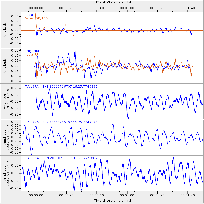
U37A Salina, OK, USA - Earthquake Result Viewer
*The percent match for this event was below the threshold and hence no stack was calculated.
| Earthquake location: |
Tonga Islands Region |
| Earthquake latitude/longitude: |
-22.4/-175.0 |
| Earthquake time(UTC): |
2011/07/16 (197) 07:03:32 GMT |
| Earthquake Depth: |
7.0 km |
| Earthquake Magnitude: |
5.7 MB, 5.6 MS, 5.8 MW, 5.7 MW |
| Earthquake Catalog/Contributor: |
WHDF/NEIC |
|
| Network: |
TA USArray Transportable Network (new EarthScope stations) |
| Station: |
U37A Salina, OK, USA |
| Lat/Lon: |
36.41 N/95.12 W |
| Elevation: |
248 m |
|
| Distance: |
95.3 deg |
| Az: |
52.907 deg |
| Baz: |
246.179 deg |
| Ray Param: |
$rayparam |
*The percent match for this event was below the threshold and hence was not used in the summary stack. |
|
| Radial Match: |
50.90333 % |
| Radial Bump: |
400 |
| Transverse Match: |
54.954803 % |
| Transverse Bump: |
400 |
| SOD ConfigId: |
401841 |
| Insert Time: |
2011-12-21 01:37:33.597 +0000 |
| GWidth: |
2.5 |
| Max Bumps: |
400 |
| Tol: |
0.001 |
|
Signal To Noise
| Channel | StoN | STA | LTA |
| TA:U37A: :BHZ:20110716T07:16:25.774983Z | 1.2734159 | 3.6056227E-7 | 2.831457E-7 |
| TA:U37A: :BHN:20110716T07:16:25.774983Z | 0.87028646 | 6.895363E-8 | 7.9230965E-8 |
| TA:U37A: :BHE:20110716T07:16:25.774983Z | 1.2579782 | 1.03036236E-7 | 8.1906215E-8 |
| Arrivals |
| Ps | |
| PpPs | |
| PsPs/PpSs | |


