You are here: Home > Network List > UW - Pacific Northwest Regional Seismic Network Stations List
> Station HOOD Mt Hood Meadows, OR CREST BB SMO > Earthquake Result Viewer
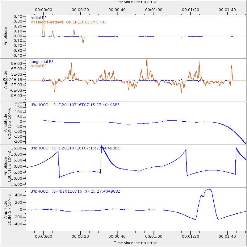
HOOD Mt Hood Meadows, OR CREST BB SMO - Earthquake Result Viewer
*The percent match for this event was below the threshold and hence no stack was calculated.
| Earthquake location: |
Tonga Islands Region |
| Earthquake latitude/longitude: |
-22.4/-175.0 |
| Earthquake time(UTC): |
2011/07/16 (197) 07:03:32 GMT |
| Earthquake Depth: |
7.0 km |
| Earthquake Magnitude: |
5.7 MB, 5.6 MS, 5.8 MW, 5.7 MW |
| Earthquake Catalog/Contributor: |
WHDF/NEIC |
|
| Network: |
UW Pacific Northwest Regional Seismic Network |
| Station: |
HOOD Mt Hood Meadows, OR CREST BB SMO |
| Lat/Lon: |
45.32 N/121.65 W |
| Elevation: |
1520 m |
|
| Distance: |
83.1 deg |
| Az: |
34.763 deg |
| Baz: |
228.395 deg |
| Ray Param: |
$rayparam |
*The percent match for this event was below the threshold and hence was not used in the summary stack. |
|
| Radial Match: |
62.52205 % |
| Radial Bump: |
298 |
| Transverse Match: |
64.596016 % |
| Transverse Bump: |
395 |
| SOD ConfigId: |
401841 |
| Insert Time: |
2011-12-21 01:43:11.563 +0000 |
| GWidth: |
2.5 |
| Max Bumps: |
400 |
| Tol: |
0.001 |
|
Signal To Noise
| Channel | StoN | STA | LTA |
| UW:HOOD: :BHZ:20110716T07:15:27.404988Z | 11.259189 | 0.0069882986 | 6.2067516E-4 |
| UW:HOOD: :BHN:20110716T07:15:27.404988Z | 0.68990785 | 7.2477073E-6 | 1.0505327E-5 |
| UW:HOOD: :BHE:20110716T07:15:27.404988Z | 0.20186879 | 1.1595712E-6 | 5.744183E-6 |
| Arrivals |
| Ps | |
| PpPs | |
| PsPs/PpSs | |


