You are here: Home > Network List > UW - Pacific Northwest Regional Seismic Network Stations List
> Station UMAT Pilot Rock, OR, USA > Earthquake Result Viewer
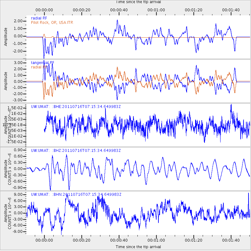
UMAT Pilot Rock, OR, USA - Earthquake Result Viewer
*The percent match for this event was below the threshold and hence no stack was calculated.
| Earthquake location: |
Tonga Islands Region |
| Earthquake latitude/longitude: |
-22.4/-175.0 |
| Earthquake time(UTC): |
2011/07/16 (197) 07:03:32 GMT |
| Earthquake Depth: |
7.0 km |
| Earthquake Magnitude: |
5.7 MB, 5.6 MS, 5.8 MW, 5.7 MW |
| Earthquake Catalog/Contributor: |
WHDF/NEIC |
|
| Network: |
UW Pacific Northwest Regional Seismic Network |
| Station: |
UMAT Pilot Rock, OR, USA |
| Lat/Lon: |
45.29 N/118.96 W |
| Elevation: |
1318 m |
|
| Distance: |
84.5 deg |
| Az: |
36.03 deg |
| Baz: |
230.441 deg |
| Ray Param: |
$rayparam |
*The percent match for this event was below the threshold and hence was not used in the summary stack. |
|
| Radial Match: |
29.259262 % |
| Radial Bump: |
400 |
| Transverse Match: |
29.28994 % |
| Transverse Bump: |
400 |
| SOD ConfigId: |
401841 |
| Insert Time: |
2011-12-21 01:43:56.054 +0000 |
| GWidth: |
2.5 |
| Max Bumps: |
400 |
| Tol: |
0.001 |
|
Signal To Noise
| Channel | StoN | STA | LTA |
| UW:UMAT: :BHZ:20110716T07:15:34.649983Z | 8.235956 | 4.0356693E-7 | 4.900062E-8 |
| UW:UMAT: :BHN:20110716T07:15:34.649983Z | 1.321372 | 4.969346E-6 | 3.760747E-6 |
| UW:UMAT: :BHE:20110716T07:15:34.649983Z | 1.0593717 | 5.465843E-9 | 5.1595137E-9 |
| Arrivals |
| Ps | |
| PpPs | |
| PsPs/PpSs | |


