You are here: Home > Network List > BK - Berkeley Digital Seismograph Network Stations List
> Station HUMO Hull Mountain, OR > Earthquake Result Viewer
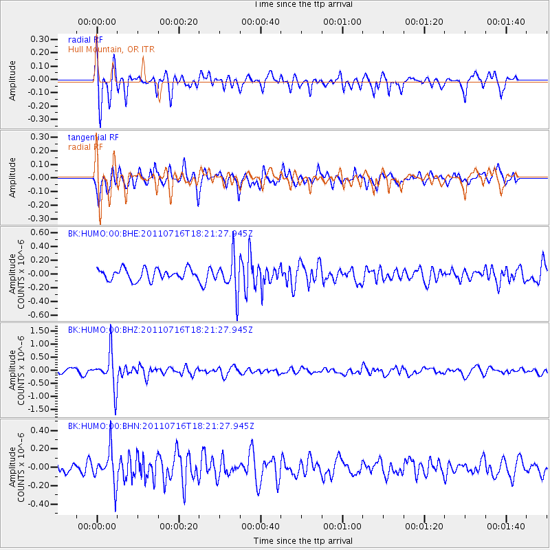
HUMO Hull Mountain, OR - Earthquake Result Viewer
*The percent match for this event was below the threshold and hence no stack was calculated.
| Earthquake location: |
Vanuatu Islands |
| Earthquake latitude/longitude: |
-18.9/169.4 |
| Earthquake time(UTC): |
2011/07/16 (197) 18:09:40 GMT |
| Earthquake Depth: |
246 km |
| Earthquake Magnitude: |
5.5 MB, 5.7 MW, 5.6 MW |
| Earthquake Catalog/Contributor: |
WHDF/NEIC |
|
| Network: |
BK Berkeley Digital Seismograph Network |
| Station: |
HUMO Hull Mountain, OR |
| Lat/Lon: |
42.61 N/122.96 W |
| Elevation: |
555 m |
|
| Distance: |
87.2 deg |
| Az: |
43.139 deg |
| Baz: |
241.285 deg |
| Ray Param: |
$rayparam |
*The percent match for this event was below the threshold and hence was not used in the summary stack. |
|
| Radial Match: |
64.112854 % |
| Radial Bump: |
400 |
| Transverse Match: |
71.60246 % |
| Transverse Bump: |
400 |
| SOD ConfigId: |
401841 |
| Insert Time: |
2011-12-21 01:59:02.521 +0000 |
| GWidth: |
2.5 |
| Max Bumps: |
400 |
| Tol: |
0.001 |
|
Signal To Noise
| Channel | StoN | STA | LTA |
| BK:HUMO:00:BHZ:20110716T18:21:27.945Z | 7.081237 | 7.011701E-7 | 9.9018024E-8 |
| BK:HUMO:00:BHN:20110716T18:21:27.945Z | 3.786418 | 1.8670174E-7 | 4.9308277E-8 |
| BK:HUMO:00:BHE:20110716T18:21:27.945Z | 3.2268443 | 2.5798792E-7 | 7.9950524E-8 |
| Arrivals |
| Ps | |
| PpPs | |
| PsPs/PpSs | |


