You are here: Home > Network List > G - GEOSCOPE Stations List
> Station CAN Canberra, Australia > Earthquake Result Viewer
CAN Canberra, Australia - Earthquake Result Viewer
| Earthquake location: |
South Of Fiji Islands |
| Earthquake latitude/longitude: |
-26.0/-177.5 |
| Earthquake time(UTC): |
2007/12/09 (343) 07:28:20 GMT |
| Earthquake Depth: |
152 km |
| Earthquake Magnitude: |
7.0 MB, 7.8 MW, 7.7 MW |
| Earthquake Catalog/Contributor: |
WHDF/NEIC |
|
| Network: |
G GEOSCOPE |
| Station: |
CAN Canberra, Australia |
| Lat/Lon: |
35.32 S/149.00 E |
| Elevation: |
650 m |
|
| Distance: |
30.2 deg |
| Az: |
243.936 deg |
| Baz: |
81.351 deg |
| Ray Param: |
0.079134524 |
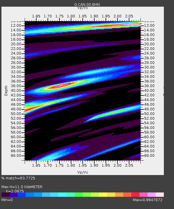
| Estimated Moho Depth: |
11.0 km |
| Estimated Crust Vp/Vs: |
2.10 |
| Assumed Crust Vp: |
6.633 km/s |
| Estimated Crust Vs: |
3.162 km/s |
| Estimated Crust Poisson's Ratio: |
0.35 |
|
| Radial Match: |
93.7725 % |
| Radial Bump: |
309 |
| Transverse Match: |
76.933586 % |
| Transverse Bump: |
400 |
| SOD ConfigId: |
2564 |
| Insert Time: |
2010-02-26 21:42:00.187 +0000 |
| GWidth: |
2.5 |
| Max Bumps: |
400 |
| Tol: |
0.001 |
|
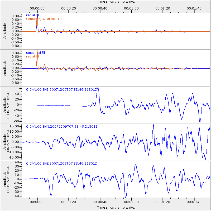
Signal To Noise
| Channel | StoN | STA | LTA |
| G:CAN:00:BHN:20071209T07:33:46.21801Z | 1.3022023 | 3.6834385E-7 | 2.8286223E-7 |
| G:CAN:00:BHE:20071209T07:33:46.21801Z | 4.3216987 | 2.3897592E-6 | 5.5296755E-7 |
| G:CAN:00:BHZ:20071209T07:33:46.21801Z | 3.1423128 | 2.776986E-6 | 8.837395E-7 |
| Arrivals |
| Ps | 2.0 SECOND |
| PpPs | 4.8 SECOND |
| PsPs/PpSs | 6.7 SECOND |


