You are here: Home > Network List > TA - USArray Transportable Network (new EarthScope stations) Stations List
> Station J05D Fort Rock, OR, USA > Earthquake Result Viewer
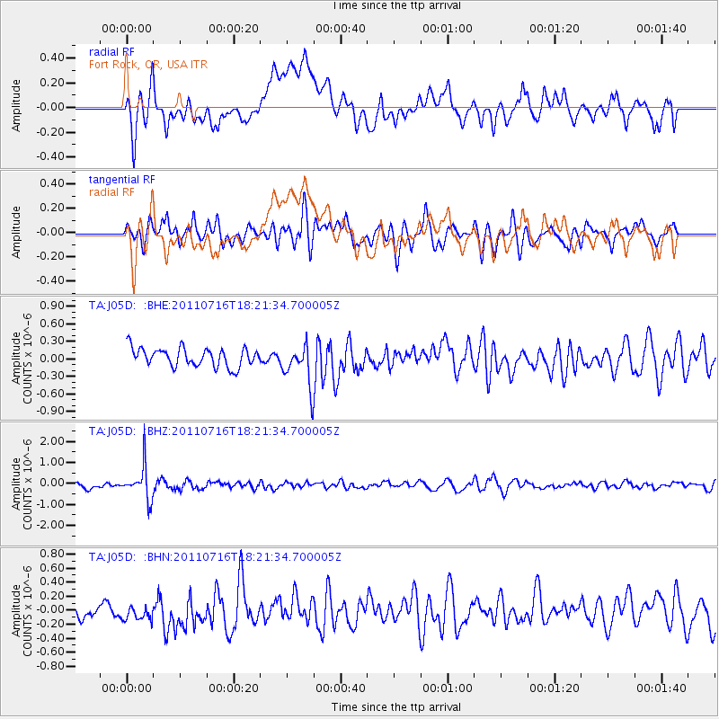
J05D Fort Rock, OR, USA - Earthquake Result Viewer
*The percent match for this event was below the threshold and hence no stack was calculated.
| Earthquake location: |
Vanuatu Islands |
| Earthquake latitude/longitude: |
-18.9/169.4 |
| Earthquake time(UTC): |
2011/07/16 (197) 18:09:40 GMT |
| Earthquake Depth: |
246 km |
| Earthquake Magnitude: |
5.5 MB, 5.7 MW, 5.6 MW |
| Earthquake Catalog/Contributor: |
WHDF/NEIC |
|
| Network: |
TA USArray Transportable Network (new EarthScope stations) |
| Station: |
J05D Fort Rock, OR, USA |
| Lat/Lon: |
43.28 N/121.23 W |
| Elevation: |
1541 m |
|
| Distance: |
88.6 deg |
| Az: |
43.138 deg |
| Baz: |
242.454 deg |
| Ray Param: |
$rayparam |
*The percent match for this event was below the threshold and hence was not used in the summary stack. |
|
| Radial Match: |
48.77464 % |
| Radial Bump: |
400 |
| Transverse Match: |
57.152924 % |
| Transverse Bump: |
400 |
| SOD ConfigId: |
401841 |
| Insert Time: |
2011-12-21 02:08:18.454 +0000 |
| GWidth: |
2.5 |
| Max Bumps: |
400 |
| Tol: |
0.001 |
|
Signal To Noise
| Channel | StoN | STA | LTA |
| TA:J05D: :BHZ:20110716T18:21:34.700005Z | 5.966507 | 7.920792E-7 | 1.3275427E-7 |
| TA:J05D: :BHN:20110716T18:21:34.700005Z | 0.9194401 | 1.4558547E-7 | 1.5834145E-7 |
| TA:J05D: :BHE:20110716T18:21:34.700005Z | 2.3107557 | 3.6352665E-7 | 1.5731939E-7 |
| Arrivals |
| Ps | |
| PpPs | |
| PsPs/PpSs | |


