You are here: Home > Network List > TA - USArray Transportable Network (new EarthScope stations) Stations List
> Station G05D Wamic, OR, USA > Earthquake Result Viewer
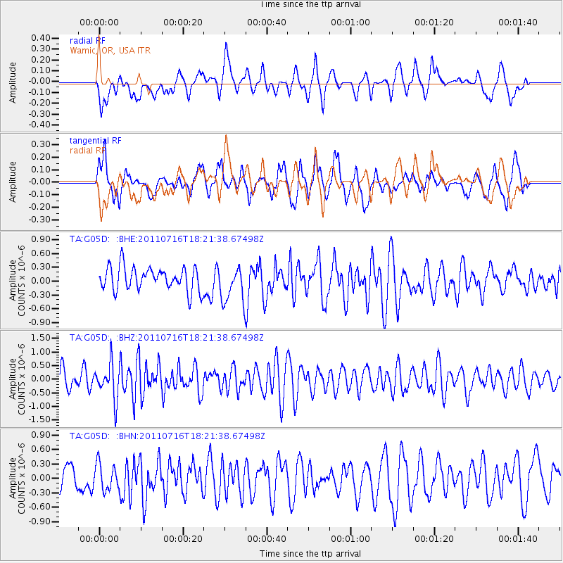
G05D Wamic, OR, USA - Earthquake Result Viewer
*The percent match for this event was below the threshold and hence no stack was calculated.
| Earthquake location: |
Vanuatu Islands |
| Earthquake latitude/longitude: |
-18.9/169.4 |
| Earthquake time(UTC): |
2011/07/16 (197) 18:09:40 GMT |
| Earthquake Depth: |
246 km |
| Earthquake Magnitude: |
5.5 MB, 5.7 MW, 5.6 MW |
| Earthquake Catalog/Contributor: |
WHDF/NEIC |
|
| Network: |
TA USArray Transportable Network (new EarthScope stations) |
| Station: |
G05D Wamic, OR, USA |
| Lat/Lon: |
45.24 N/121.32 W |
| Elevation: |
592 m |
|
| Distance: |
89.5 deg |
| Az: |
41.376 deg |
| Baz: |
242.369 deg |
| Ray Param: |
$rayparam |
*The percent match for this event was below the threshold and hence was not used in the summary stack. |
|
| Radial Match: |
44.37349 % |
| Radial Bump: |
400 |
| Transverse Match: |
63.04168 % |
| Transverse Bump: |
400 |
| SOD ConfigId: |
401841 |
| Insert Time: |
2011-12-21 02:08:21.082 +0000 |
| GWidth: |
2.5 |
| Max Bumps: |
400 |
| Tol: |
0.001 |
|
Signal To Noise
| Channel | StoN | STA | LTA |
| TA:G05D: :BHZ:20110716T18:21:38.67498Z | 1.9184175 | 6.626828E-7 | 3.45432E-7 |
| TA:G05D: :BHN:20110716T18:21:38.67498Z | 1.1781185 | 2.8086708E-7 | 2.3840309E-7 |
| TA:G05D: :BHE:20110716T18:21:38.67498Z | 1.6358254 | 4.1421643E-7 | 2.5321555E-7 |
| Arrivals |
| Ps | |
| PpPs | |
| PsPs/PpSs | |


