You are here: Home > Network List > PF - Volcanologic Network of Piton de Fournaise-OVPF Stations List
> Station HIM cratere Himiltrude > Earthquake Result Viewer
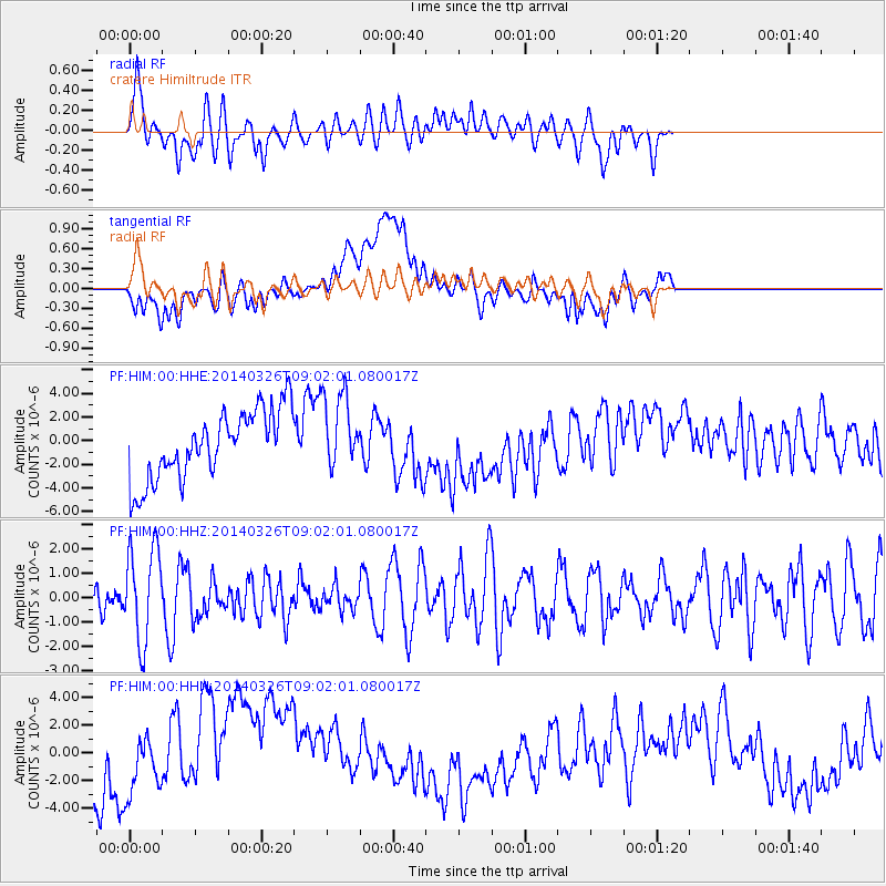
HIM cratere Himiltrude - Earthquake Result Viewer
*The percent match for this event was below the threshold and hence no stack was calculated.
| Earthquake location: |
Southeast Of Ryukyu Islands |
| Earthquake latitude/longitude: |
28.2/131.5 |
| Earthquake time(UTC): |
2014/03/26 (085) 08:49:41 GMT |
| Earthquake Depth: |
10 km |
| Earthquake Magnitude: |
5.6 MWP, 1.0 MI, 5.4 MWC, 5.5 MWW |
| Earthquake Catalog/Contributor: |
NEIC PDE/NEIC COMCAT |
|
| Network: |
PF Volcanologic Network of Piton de Fournaise-OVPF |
| Station: |
HIM cratere Himiltrude |
| Lat/Lon: |
21.21 S/55.72 E |
| Elevation: |
1958 m |
|
| Distance: |
88.1 deg |
| Az: |
244.808 deg |
| Baz: |
58.895 deg |
| Ray Param: |
$rayparam |
*The percent match for this event was below the threshold and hence was not used in the summary stack. |
|
| Radial Match: |
44.59686 % |
| Radial Bump: |
400 |
| Transverse Match: |
20.597298 % |
| Transverse Bump: |
400 |
| SOD ConfigId: |
3390531 |
| Insert Time: |
2019-04-10 21:57:44.669 +0000 |
| GWidth: |
2.5 |
| Max Bumps: |
400 |
| Tol: |
0.001 |
|
Signal To Noise
| Channel | StoN | STA | LTA |
| PF:HIM:00:HHZ:20140326T09:02:01.080017Z | 2.2544167 | 1.9064706E-6 | 8.456602E-7 |
| PF:HIM:00:HHN:20140326T09:02:01.080017Z | 0.7752312 | 2.0647094E-6 | 2.6633465E-6 |
| PF:HIM:00:HHE:20140326T09:02:01.080017Z | 1.2017856 | 3.4696923E-6 | 2.8871145E-6 |
| Arrivals |
| Ps | |
| PpPs | |
| PsPs/PpSs | |


