You are here: Home > Network List > G - GEOSCOPE Stations List
> Station CAN Canberra, Australia > Earthquake Result Viewer
CAN Canberra, Australia - Earthquake Result Viewer
| Earthquake location: |
Talaud Islands, Indonesia |
| Earthquake latitude/longitude: |
3.8/126.3 |
| Earthquake time(UTC): |
2007/09/13 (256) 09:48:46 GMT |
| Earthquake Depth: |
35 km |
| Earthquake Magnitude: |
6.2 MB, 6.2 MS, 6.3 MW |
| Earthquake Catalog/Contributor: |
WHDF/NEIC |
|
| Network: |
G GEOSCOPE |
| Station: |
CAN Canberra, Australia |
| Lat/Lon: |
35.32 S/149.00 E |
| Elevation: |
650 m |
|
| Distance: |
44.4 deg |
| Az: |
153.208 deg |
| Baz: |
326.632 deg |
| Ray Param: |
0.07190001 |
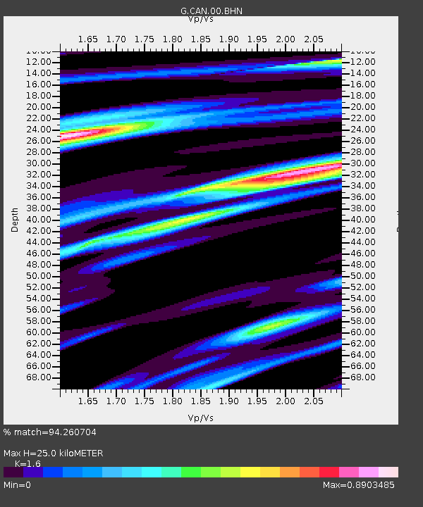
| Estimated Moho Depth: |
25.0 km |
| Estimated Crust Vp/Vs: |
1.60 |
| Assumed Crust Vp: |
6.633 km/s |
| Estimated Crust Vs: |
4.146 km/s |
| Estimated Crust Poisson's Ratio: |
0.18 |
|
| Radial Match: |
94.260704 % |
| Radial Bump: |
340 |
| Transverse Match: |
81.61442 % |
| Transverse Bump: |
400 |
| SOD ConfigId: |
2564 |
| Insert Time: |
2010-02-26 21:42:16.858 +0000 |
| GWidth: |
2.5 |
| Max Bumps: |
400 |
| Tol: |
0.001 |
|

Signal To Noise
| Channel | StoN | STA | LTA |
| G:CAN:00:BHN:20070913T09:56:22.820005Z | 9.467241 | 2.2778647E-6 | 2.4060492E-7 |
| G:CAN:00:BHE:20070913T09:56:22.820005Z | 5.575284 | 1.1629282E-6 | 2.0858637E-7 |
| G:CAN:00:BHZ:20070913T09:56:22.820005Z | 13.577529 | 4.309421E-6 | 3.173936E-7 |
| Arrivals |
| Ps | 2.4 SECOND |
| PpPs | 9.1 SECOND |
| PsPs/PpSs | 12 SECOND |


