You are here: Home > Network List > TA - USArray Transportable Network (new EarthScope stations) Stations List
> Station X33A Lawton, OK, USA > Earthquake Result Viewer
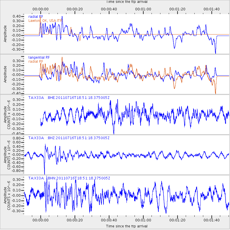
X33A Lawton, OK, USA - Earthquake Result Viewer
*The percent match for this event was below the threshold and hence no stack was calculated.
| Earthquake location: |
Lake Baykal Region, Russia |
| Earthquake latitude/longitude: |
52.9/108.4 |
| Earthquake time(UTC): |
2011/07/16 (197) 18:38:50 GMT |
| Earthquake Depth: |
8.5 km |
| Earthquake Magnitude: |
5.5 MB, 5.3 MW, 5.3 MW |
| Earthquake Catalog/Contributor: |
WHDF/NEIC |
|
| Network: |
TA USArray Transportable Network (new EarthScope stations) |
| Station: |
X33A Lawton, OK, USA |
| Lat/Lon: |
34.54 N/98.50 W |
| Elevation: |
346 m |
|
| Distance: |
89.8 deg |
| Az: |
21.963 deg |
| Baz: |
344.063 deg |
| Ray Param: |
$rayparam |
*The percent match for this event was below the threshold and hence was not used in the summary stack. |
|
| Radial Match: |
36.071636 % |
| Radial Bump: |
400 |
| Transverse Match: |
45.219303 % |
| Transverse Bump: |
400 |
| SOD ConfigId: |
401841 |
| Insert Time: |
2011-12-21 02:32:38.634 +0000 |
| GWidth: |
2.5 |
| Max Bumps: |
400 |
| Tol: |
0.001 |
|
Signal To Noise
| Channel | StoN | STA | LTA |
| TA:X33A: :BHZ:20110716T18:51:18.375005Z | 3.492394 | 2.7694477E-7 | 7.9299404E-8 |
| TA:X33A: :BHN:20110716T18:51:18.375005Z | 1.5591403 | 2.1007251E-7 | 1.3473611E-7 |
| TA:X33A: :BHE:20110716T18:51:18.375005Z | 0.85666144 | 8.291687E-8 | 9.679071E-8 |
| Arrivals |
| Ps | |
| PpPs | |
| PsPs/PpSs | |


