You are here: Home > Network List > TA - USArray Transportable Network (new EarthScope stations) Stations List
> Station R34A Isabella, Hillsboro, KS, USA > Earthquake Result Viewer
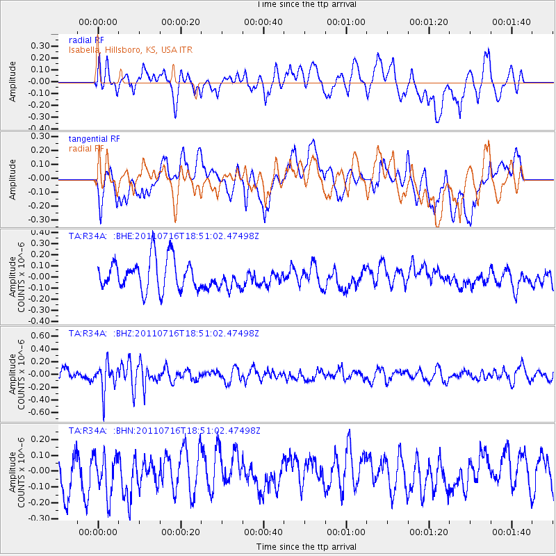
R34A Isabella, Hillsboro, KS, USA - Earthquake Result Viewer
*The percent match for this event was below the threshold and hence no stack was calculated.
| Earthquake location: |
Lake Baykal Region, Russia |
| Earthquake latitude/longitude: |
52.9/108.4 |
| Earthquake time(UTC): |
2011/07/16 (197) 18:38:50 GMT |
| Earthquake Depth: |
8.5 km |
| Earthquake Magnitude: |
5.5 MB, 5.3 MW, 5.3 MW |
| Earthquake Catalog/Contributor: |
WHDF/NEIC |
|
| Network: |
TA USArray Transportable Network (new EarthScope stations) |
| Station: |
R34A Isabella, Hillsboro, KS, USA |
| Lat/Lon: |
38.30 N/97.25 W |
| Elevation: |
437 m |
|
| Distance: |
86.5 deg |
| Az: |
19.979 deg |
| Baz: |
344.741 deg |
| Ray Param: |
$rayparam |
*The percent match for this event was below the threshold and hence was not used in the summary stack. |
|
| Radial Match: |
43.322803 % |
| Radial Bump: |
400 |
| Transverse Match: |
62.184875 % |
| Transverse Bump: |
400 |
| SOD ConfigId: |
401841 |
| Insert Time: |
2011-12-21 02:38:53.802 +0000 |
| GWidth: |
2.5 |
| Max Bumps: |
400 |
| Tol: |
0.001 |
|
Signal To Noise
| Channel | StoN | STA | LTA |
| TA:R34A: :BHZ:20110716T18:51:02.47498Z | 3.3073068 | 2.2016604E-7 | 6.6569584E-8 |
| TA:R34A: :BHN:20110716T18:51:02.47498Z | 1.1827327 | 1.317326E-7 | 1.1137986E-7 |
| TA:R34A: :BHE:20110716T18:51:02.47498Z | 0.764579 | 1.0740863E-7 | 1.4048075E-7 |
| Arrivals |
| Ps | |
| PpPs | |
| PsPs/PpSs | |


