You are here: Home > Network List > TA - USArray Transportable Network (new EarthScope stations) Stations List
> Station V38A Canehill, AR, USA > Earthquake Result Viewer
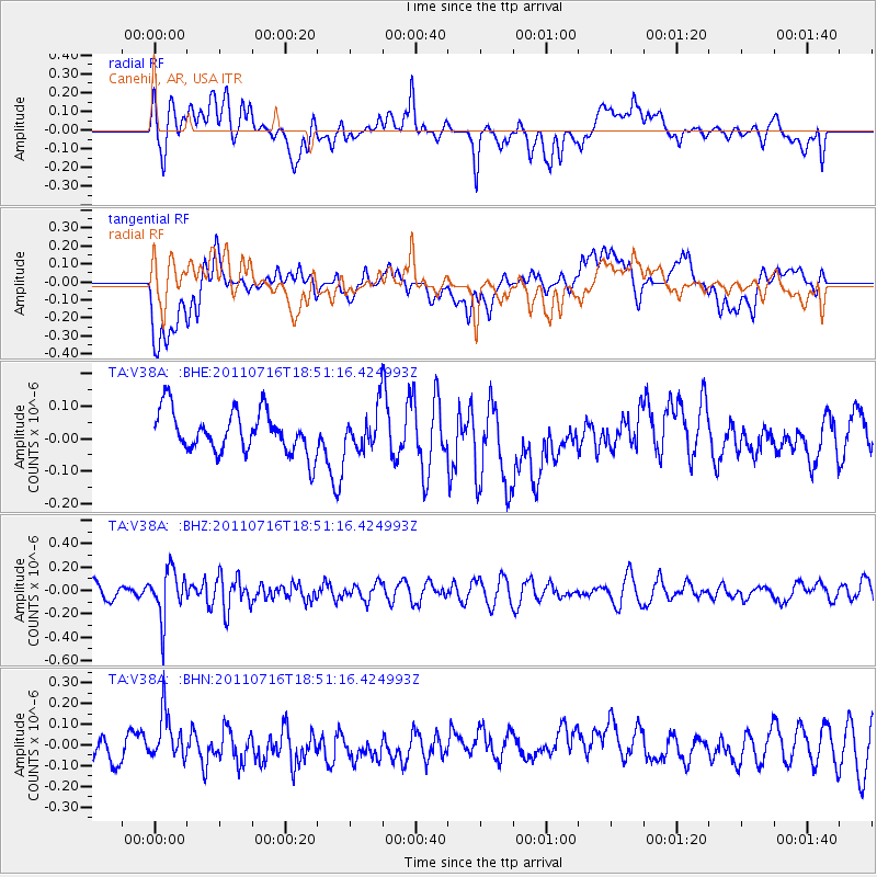
V38A Canehill, AR, USA - Earthquake Result Viewer
*The percent match for this event was below the threshold and hence no stack was calculated.
| Earthquake location: |
Lake Baykal Region, Russia |
| Earthquake latitude/longitude: |
52.9/108.4 |
| Earthquake time(UTC): |
2011/07/16 (197) 18:38:50 GMT |
| Earthquake Depth: |
8.5 km |
| Earthquake Magnitude: |
5.5 MB, 5.3 MW, 5.3 MW |
| Earthquake Catalog/Contributor: |
WHDF/NEIC |
|
| Network: |
TA USArray Transportable Network (new EarthScope stations) |
| Station: |
V38A Canehill, AR, USA |
| Lat/Lon: |
35.86 N/94.41 W |
| Elevation: |
372 m |
|
| Distance: |
89.4 deg |
| Az: |
18.386 deg |
| Baz: |
346.389 deg |
| Ray Param: |
$rayparam |
*The percent match for this event was below the threshold and hence was not used in the summary stack. |
|
| Radial Match: |
53.07573 % |
| Radial Bump: |
400 |
| Transverse Match: |
42.023766 % |
| Transverse Bump: |
400 |
| SOD ConfigId: |
401841 |
| Insert Time: |
2011-12-21 02:40:20.991 +0000 |
| GWidth: |
2.5 |
| Max Bumps: |
400 |
| Tol: |
0.001 |
|
Signal To Noise
| Channel | StoN | STA | LTA |
| TA:V38A: :BHZ:20110716T18:51:16.424993Z | 2.3283007 | 2.0549493E-7 | 8.825961E-8 |
| TA:V38A: :BHN:20110716T18:51:16.424993Z | 2.0854142 | 1.1655816E-7 | 5.5892095E-8 |
| TA:V38A: :BHE:20110716T18:51:16.424993Z | 0.9482569 | 6.015754E-8 | 6.3440126E-8 |
| Arrivals |
| Ps | |
| PpPs | |
| PsPs/PpSs | |


