You are here: Home > Network List > TA - USArray Transportable Network (new EarthScope stations) Stations List
> Station Y41A Eaglette Bearden, AR, USA > Earthquake Result Viewer
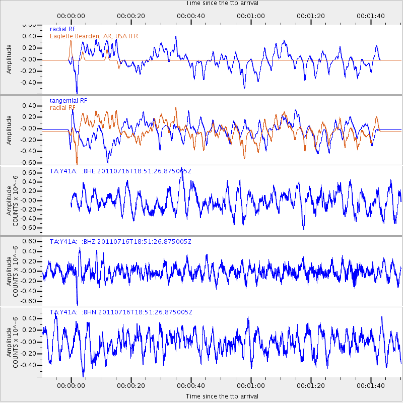
Y41A Eaglette Bearden, AR, USA - Earthquake Result Viewer
*The percent match for this event was below the threshold and hence no stack was calculated.
| Earthquake location: |
Lake Baykal Region, Russia |
| Earthquake latitude/longitude: |
52.9/108.4 |
| Earthquake time(UTC): |
2011/07/16 (197) 18:38:50 GMT |
| Earthquake Depth: |
8.5 km |
| Earthquake Magnitude: |
5.5 MB, 5.3 MW, 5.3 MW |
| Earthquake Catalog/Contributor: |
WHDF/NEIC |
|
| Network: |
TA USArray Transportable Network (new EarthScope stations) |
| Station: |
Y41A Eaglette Bearden, AR, USA |
| Lat/Lon: |
33.88 N/92.61 W |
| Elevation: |
99 m |
|
| Distance: |
91.7 deg |
| Az: |
17.395 deg |
| Baz: |
347.421 deg |
| Ray Param: |
$rayparam |
*The percent match for this event was below the threshold and hence was not used in the summary stack. |
|
| Radial Match: |
52.970566 % |
| Radial Bump: |
400 |
| Transverse Match: |
34.29332 % |
| Transverse Bump: |
400 |
| SOD ConfigId: |
401841 |
| Insert Time: |
2011-12-21 02:51:42.887 +0000 |
| GWidth: |
2.5 |
| Max Bumps: |
400 |
| Tol: |
0.001 |
|
Signal To Noise
| Channel | StoN | STA | LTA |
| TA:Y41A: :BHZ:20110716T18:51:26.875005Z | 2.778584 | 2.2555E-7 | 8.1174434E-8 |
| TA:Y41A: :BHN:20110716T18:51:26.875005Z | 1.6371139 | 2.5823508E-7 | 1.5773799E-7 |
| TA:Y41A: :BHE:20110716T18:51:26.875005Z | 1.0971879 | 1.9573852E-7 | 1.7840019E-7 |
| Arrivals |
| Ps | |
| PpPs | |
| PsPs/PpSs | |


