You are here: Home > Network List > TA - USArray Transportable Network (new EarthScope stations) Stations List
> Station X43A Marvell, AR, USA > Earthquake Result Viewer
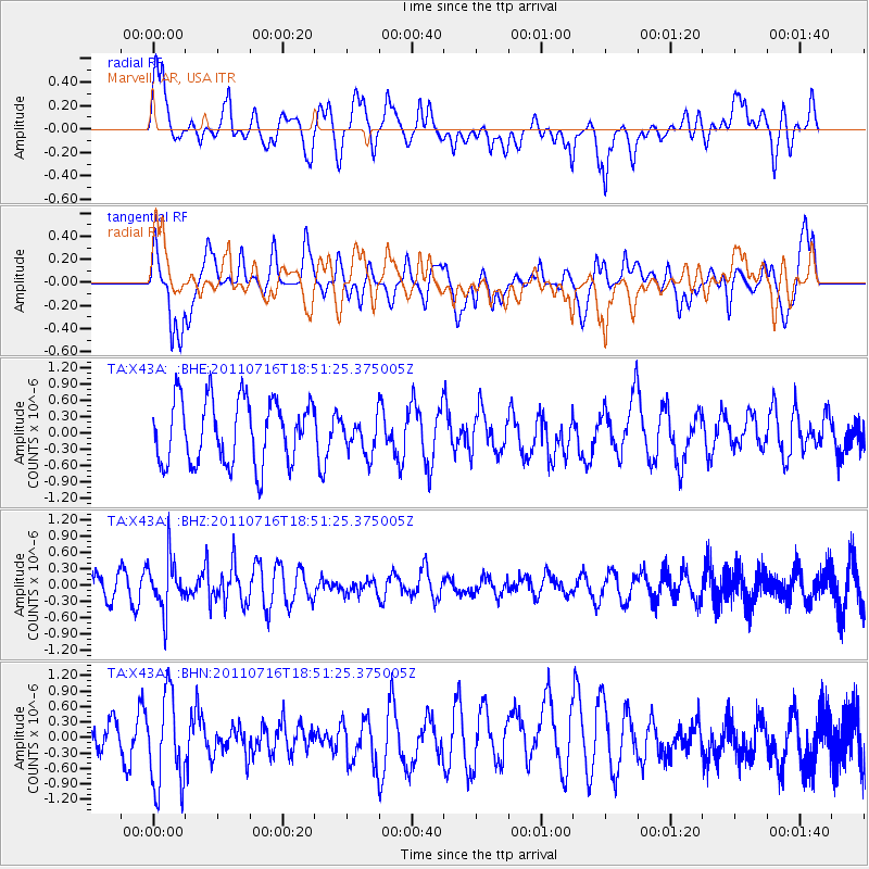
X43A Marvell, AR, USA - Earthquake Result Viewer
*The percent match for this event was below the threshold and hence no stack was calculated.
| Earthquake location: |
Lake Baykal Region, Russia |
| Earthquake latitude/longitude: |
52.9/108.4 |
| Earthquake time(UTC): |
2011/07/16 (197) 18:38:50 GMT |
| Earthquake Depth: |
8.5 km |
| Earthquake Magnitude: |
5.5 MB, 5.3 MW, 5.3 MW |
| Earthquake Catalog/Contributor: |
WHDF/NEIC |
|
| Network: |
TA USArray Transportable Network (new EarthScope stations) |
| Station: |
X43A Marvell, AR, USA |
| Lat/Lon: |
34.52 N/90.88 W |
| Elevation: |
53 m |
|
| Distance: |
91.3 deg |
| Az: |
15.859 deg |
| Baz: |
348.429 deg |
| Ray Param: |
$rayparam |
*The percent match for this event was below the threshold and hence was not used in the summary stack. |
|
| Radial Match: |
50.00582 % |
| Radial Bump: |
400 |
| Transverse Match: |
50.269505 % |
| Transverse Bump: |
400 |
| SOD ConfigId: |
401841 |
| Insert Time: |
2011-12-21 02:52:38.121 +0000 |
| GWidth: |
2.5 |
| Max Bumps: |
400 |
| Tol: |
0.001 |
|
Signal To Noise
| Channel | StoN | STA | LTA |
| TA:X43A: :BHZ:20110716T18:51:25.375005Z | 1.9678166 | 4.6877517E-7 | 2.3822098E-7 |
| TA:X43A: :BHN:20110716T18:51:25.375005Z | 3.3316498 | 9.0000924E-7 | 2.7013922E-7 |
| TA:X43A: :BHE:20110716T18:51:25.375005Z | 0.56834745 | 3.3397248E-7 | 5.8762026E-7 |
| Arrivals |
| Ps | |
| PpPs | |
| PsPs/PpSs | |


