You are here: Home > Network List > AZ - ANZA Regional Network Stations List
> Station SMER AZ.SMER > Earthquake Result Viewer
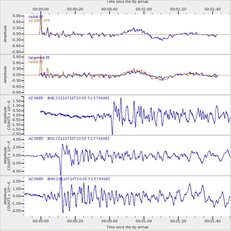
SMER AZ.SMER - Earthquake Result Viewer
*The percent match for this event was below the threshold and hence no stack was calculated.
| Earthquake location: |
Alaska Peninsula |
| Earthquake latitude/longitude: |
54.8/-161.3 |
| Earthquake time(UTC): |
2011/07/16 (197) 19:59:12 GMT |
| Earthquake Depth: |
36 km |
| Earthquake Magnitude: |
6.3 MB, 5.9 MS, 6.2 MW, 6.1 MW |
| Earthquake Catalog/Contributor: |
WHDF/NEIC |
|
| Network: |
AZ ANZA Regional Network |
| Station: |
SMER AZ.SMER |
| Lat/Lon: |
33.46 N/117.17 W |
| Elevation: |
355 m |
|
| Distance: |
37.4 deg |
| Az: |
106.41 deg |
| Baz: |
318.348 deg |
| Ray Param: |
$rayparam |
*The percent match for this event was below the threshold and hence was not used in the summary stack. |
|
| Radial Match: |
79.16208 % |
| Radial Bump: |
400 |
| Transverse Match: |
64.70011 % |
| Transverse Bump: |
400 |
| SOD ConfigId: |
401841 |
| Insert Time: |
2011-12-21 03:06:55.232 +0000 |
| GWidth: |
2.5 |
| Max Bumps: |
400 |
| Tol: |
0.001 |
|
Signal To Noise
| Channel | StoN | STA | LTA |
| AZ:SMER: :BHZ:20110716T20:05:51.574998Z | 5.0313525 | 4.2078628E-7 | 8.3632834E-8 |
| AZ:SMER: :BHN:20110716T20:05:51.574998Z | 0.5764224 | 4.1335716E-7 | 7.171081E-7 |
| AZ:SMER: :BHE:20110716T20:05:51.574998Z | 1.4789581 | 2.6684054E-7 | 1.8042468E-7 |
| Arrivals |
| Ps | |
| PpPs | |
| PsPs/PpSs | |


