You are here: Home > Network List > G - GEOSCOPE Stations List
> Station INU Inuyama, Japan > Earthquake Result Viewer
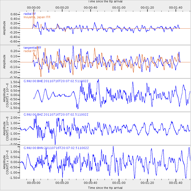
INU Inuyama, Japan - Earthquake Result Viewer
*The percent match for this event was below the threshold and hence no stack was calculated.
| Earthquake location: |
Alaska Peninsula |
| Earthquake latitude/longitude: |
54.8/-161.3 |
| Earthquake time(UTC): |
2011/07/16 (197) 19:59:12 GMT |
| Earthquake Depth: |
36 km |
| Earthquake Magnitude: |
6.3 MB, 5.9 MS, 6.2 MW, 6.1 MW |
| Earthquake Catalog/Contributor: |
WHDF/NEIC |
|
| Network: |
G GEOSCOPE |
| Station: |
INU Inuyama, Japan |
| Lat/Lon: |
35.35 N/137.03 E |
| Elevation: |
132 m |
|
| Distance: |
46.0 deg |
| Az: |
271.393 deg |
| Baz: |
45.099 deg |
| Ray Param: |
$rayparam |
*The percent match for this event was below the threshold and hence was not used in the summary stack. |
|
| Radial Match: |
65.38106 % |
| Radial Bump: |
400 |
| Transverse Match: |
58.65551 % |
| Transverse Bump: |
400 |
| SOD ConfigId: |
401841 |
| Insert Time: |
2011-12-21 03:14:49.356 +0000 |
| GWidth: |
2.5 |
| Max Bumps: |
400 |
| Tol: |
0.001 |
|
Signal To Noise
| Channel | StoN | STA | LTA |
| G:INU:00:BHZ:20110716T20:07:02.511002Z | 4.421052 | 1.0153976E-6 | 2.2967329E-7 |
| G:INU:00:BHN:20110716T20:07:02.511002Z | 1.3711632 | 3.823663E-7 | 2.7886273E-7 |
| G:INU:00:BHE:20110716T20:07:02.511002Z | 2.9069505 | 9.338329E-7 | 3.2124143E-7 |
| Arrivals |
| Ps | |
| PpPs | |
| PsPs/PpSs | |


