You are here: Home > Network List > G - GEOSCOPE Stations List
> Station FDF Fort de France, Martinique France > Earthquake Result Viewer
FDF Fort de France, Martinique France - Earthquake Result Viewer
| Earthquake location: |
Alaska Peninsula |
| Earthquake latitude/longitude: |
54.8/-161.3 |
| Earthquake time(UTC): |
2011/07/16 (197) 19:59:12 GMT |
| Earthquake Depth: |
36 km |
| Earthquake Magnitude: |
6.3 MB, 5.9 MS, 6.2 MW, 6.1 MW |
| Earthquake Catalog/Contributor: |
WHDF/NEIC |
|
| Network: |
G GEOSCOPE |
| Station: |
FDF Fort de France, Martinique France |
| Lat/Lon: |
14.73 N/61.14 W |
| Elevation: |
467 m |
|
| Distance: |
83.8 deg |
| Az: |
73.321 deg |
| Baz: |
325.008 deg |
| Ray Param: |
0.04585154 |
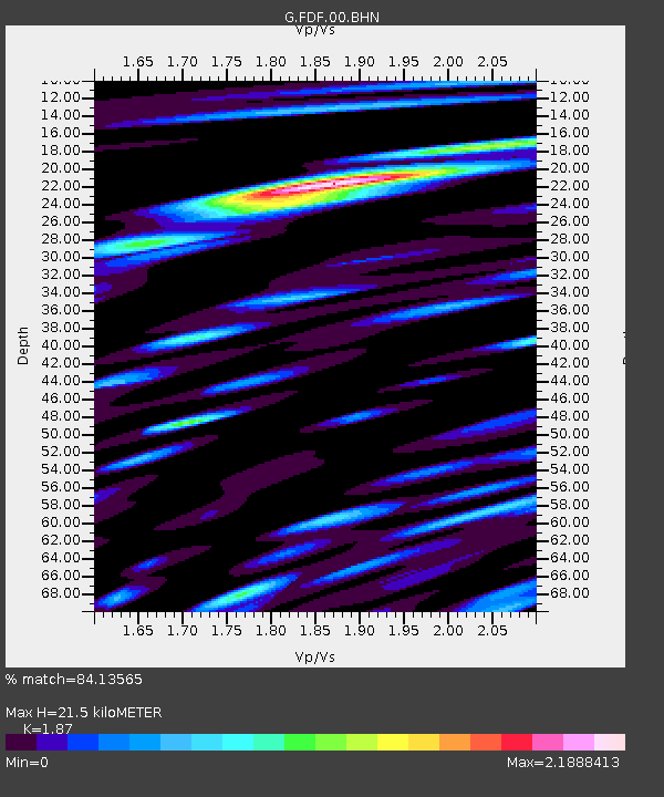
| Estimated Moho Depth: |
21.5 km |
| Estimated Crust Vp/Vs: |
1.87 |
| Assumed Crust Vp: |
5.88 km/s |
| Estimated Crust Vs: |
3.145 km/s |
| Estimated Crust Poisson's Ratio: |
0.30 |
|
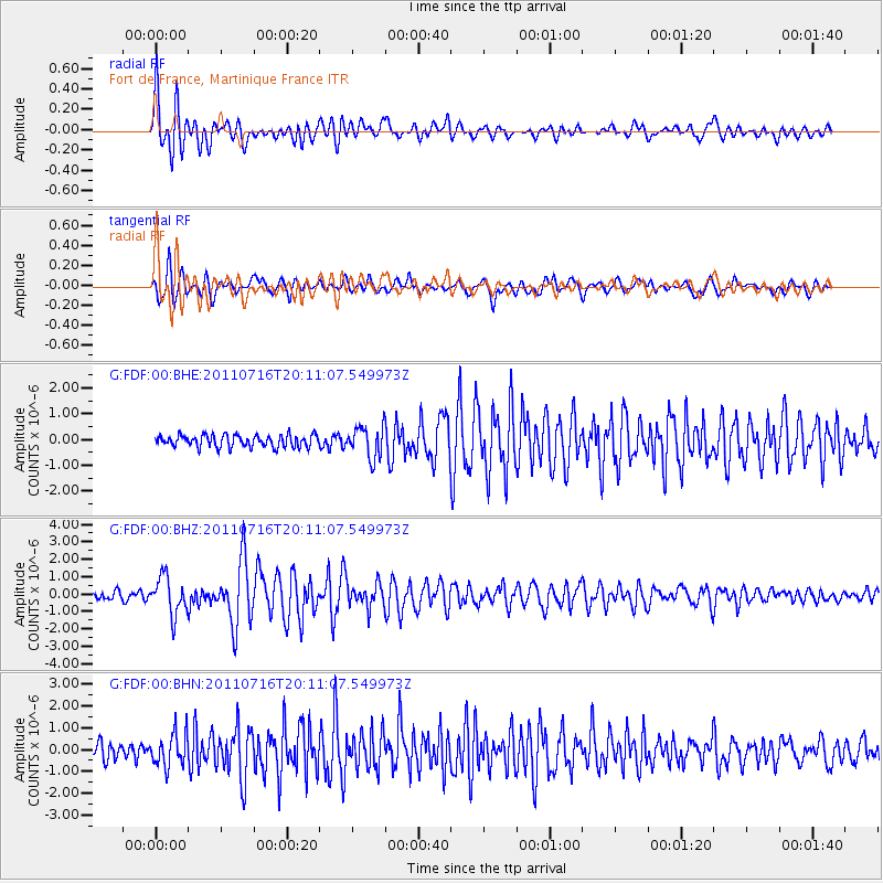
| Radial Match: |
84.13565 % |
| Radial Bump: |
400 |
| Transverse Match: |
81.939125 % |
| Transverse Bump: |
400 |
| SOD ConfigId: |
401841 |
| Insert Time: |
2011-12-21 03:14:59.202 +0000 |
| GWidth: |
2.5 |
| Max Bumps: |
400 |
| Tol: |
0.001 |
|
Signal To Noise
| Channel | StoN | STA | LTA |
| G:FDF:00:BHZ:20110716T20:11:07.549973Z | 5.9288507 | 1.0668537E-6 | 1.7994275E-7 |
| G:FDF:00:BHN:20110716T20:11:07.549973Z | 2.3139207 | 7.617264E-7 | 3.2919297E-7 |
| G:FDF:00:BHE:20110716T20:11:07.549973Z | 2.5978713 | 6.0565384E-7 | 2.3313467E-7 |
| Arrivals |
| Ps | 3.2 SECOND |
| PpPs | 10 SECOND |
| PsPs/PpSs | 14 SECOND |


