You are here: Home > Network List > LD - Lamont-Doherty Cooperative Seismographic Network Stations List
> Station LUPA Lehigh University, PA > Earthquake Result Viewer
LUPA Lehigh University, PA - Earthquake Result Viewer

| Earthquake location: |
Alaska Peninsula |
| Earthquake latitude/longitude: |
54.8/-161.3 |
| Earthquake time(UTC): |
2011/07/16 (197) 19:59:12 GMT |
| Earthquake Depth: |
36 km |
| Earthquake Magnitude: |
6.3 MB, 5.9 MS, 6.2 MW, 6.1 MW |
| Earthquake Catalog/Contributor: |
WHDF/NEIC |
|
| Network: |
LD Lamont-Doherty Cooperative Seismographic Network |
| Station: |
LUPA Lehigh University, PA |
| Lat/Lon: |
40.60 N/75.37 W |
| Elevation: |
236 m |
|
| Distance: |
56.0 deg |
| Az: |
66.434 deg |
| Baz: |
315.795 deg |
| Ray Param: |
0.06438719 |
| Estimated Moho Depth: |
40.0 km |
| Estimated Crust Vp/Vs: |
1.83 |
| Assumed Crust Vp: |
6.283 km/s |
| Estimated Crust Vs: |
3.434 km/s |
| Estimated Crust Poisson's Ratio: |
0.29 |
|
| Radial Match: |
89.4521 % |
| Radial Bump: |
368 |
| Transverse Match: |
89.38712 % |
| Transverse Bump: |
346 |
| SOD ConfigId: |
401841 |
| Insert Time: |
2011-12-21 03:21:12.048 +0000 |
| GWidth: |
2.5 |
| Max Bumps: |
400 |
| Tol: |
0.001 |
|
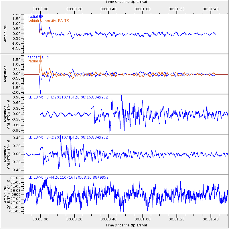
Signal To Noise
| Channel | StoN | STA | LTA |
| LD:LUPA: :BHZ:20110716T20:08:16.884995Z | 15.780134 | 1.3376453E-7 | 8.476768E-9 |
| LD:LUPA: :BHN:20110716T20:08:16.884995Z | 1.4682722 | 4.641209E-9 | 3.1610006E-9 |
| LD:LUPA: :BHE:20110716T20:08:16.884995Z | 3.8641665 | 2.9810028E-7 | 7.7144776E-8 |
| Arrivals |
| Ps | 5.5 SECOND |
| PpPs | 17 SECOND |
| PsPs/PpSs | 23 SECOND |


