You are here: Home > Network List > LD - Lamont-Doherty Cooperative Seismographic Network Stations List
> Station ODNJ Ogdensburg, New Jersey > Earthquake Result Viewer
ODNJ Ogdensburg, New Jersey - Earthquake Result Viewer
| Earthquake location: |
Alaska Peninsula |
| Earthquake latitude/longitude: |
54.8/-161.3 |
| Earthquake time(UTC): |
2011/07/16 (197) 19:59:12 GMT |
| Earthquake Depth: |
36 km |
| Earthquake Magnitude: |
6.3 MB, 5.9 MS, 6.2 MW, 6.1 MW |
| Earthquake Catalog/Contributor: |
WHDF/NEIC |
|
| Network: |
LD Lamont-Doherty Cooperative Seismographic Network |
| Station: |
ODNJ Ogdensburg, New Jersey |
| Lat/Lon: |
41.08 N/74.61 W |
| Elevation: |
187 m |
|
| Distance: |
56.0 deg |
| Az: |
65.525 deg |
| Baz: |
315.785 deg |
| Ray Param: |
0.064349286 |
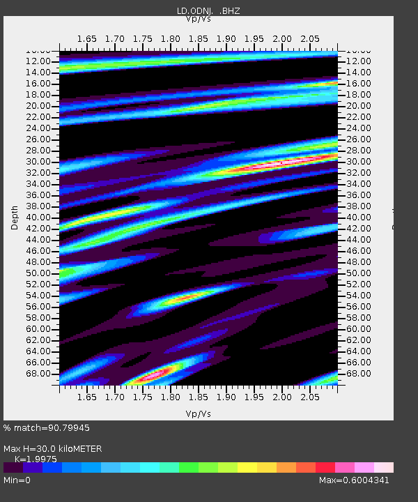
| Estimated Moho Depth: |
30.0 km |
| Estimated Crust Vp/Vs: |
2.00 |
| Assumed Crust Vp: |
6.283 km/s |
| Estimated Crust Vs: |
3.146 km/s |
| Estimated Crust Poisson's Ratio: |
0.33 |
|
| Radial Match: |
90.79945 % |
| Radial Bump: |
339 |
| Transverse Match: |
77.80987 % |
| Transverse Bump: |
400 |
| SOD ConfigId: |
401841 |
| Insert Time: |
2011-12-21 03:21:56.367 +0000 |
| GWidth: |
2.5 |
| Max Bumps: |
400 |
| Tol: |
0.001 |
|

Signal To Noise
| Channel | StoN | STA | LTA |
| LD:ODNJ: :BHZ:20110716T20:08:17.295029Z | 13.989267 | 1.3306951E-6 | 9.512257E-8 |
| LD:ODNJ: :BHN:20110716T20:08:17.295029Z | 5.9370356 | 5.1546925E-7 | 8.6822666E-8 |
| LD:ODNJ: :BHE:20110716T20:08:17.295029Z | 2.982676 | 4.1786416E-7 | 1.4009707E-7 |
| Arrivals |
| Ps | 5.0 SECOND |
| PpPs | 14 SECOND |
| PsPs/PpSs | 19 SECOND |


