You are here: Home > Network List > LD - Lamont-Doherty Cooperative Seismographic Network Stations List
> Station KSPA Keystone College, La Plume, PA > Earthquake Result Viewer
KSPA Keystone College, La Plume, PA - Earthquake Result Viewer
| Earthquake location: |
Alaska Peninsula |
| Earthquake latitude/longitude: |
54.8/-161.3 |
| Earthquake time(UTC): |
2011/07/16 (197) 19:59:12 GMT |
| Earthquake Depth: |
36 km |
| Earthquake Magnitude: |
6.3 MB, 5.9 MS, 6.2 MW, 6.1 MW |
| Earthquake Catalog/Contributor: |
WHDF/NEIC |
|
| Network: |
LD Lamont-Doherty Cooperative Seismographic Network |
| Station: |
KSPA Keystone College, La Plume, PA |
| Lat/Lon: |
41.56 N/75.77 W |
| Elevation: |
298 m |
|
| Distance: |
55.1 deg |
| Az: |
65.88 deg |
| Baz: |
315.221 deg |
| Ray Param: |
0.064970896 |
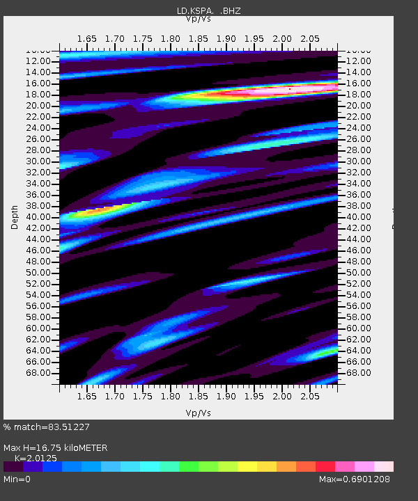
| Estimated Moho Depth: |
16.75 km |
| Estimated Crust Vp/Vs: |
2.01 |
| Assumed Crust Vp: |
6.283 km/s |
| Estimated Crust Vs: |
3.122 km/s |
| Estimated Crust Poisson's Ratio: |
0.34 |
|
| Radial Match: |
83.51227 % |
| Radial Bump: |
400 |
| Transverse Match: |
75.5588 % |
| Transverse Bump: |
400 |
| SOD ConfigId: |
401841 |
| Insert Time: |
2011-12-21 03:22:17.456 +0000 |
| GWidth: |
2.5 |
| Max Bumps: |
400 |
| Tol: |
0.001 |
|

Signal To Noise
| Channel | StoN | STA | LTA |
| LD:KSPA: :BHZ:20110716T20:08:10.460007Z | 7.19266 | 1.4818692E-6 | 2.0602519E-7 |
| LD:KSPA: :BHN:20110716T20:08:10.460007Z | 4.8119802 | 6.069575E-7 | 1.2613465E-7 |
| LD:KSPA: :BHE:20110716T20:08:10.460007Z | 5.1589704 | 4.6193244E-7 | 8.9539654E-8 |
| Arrivals |
| Ps | 2.8 SECOND |
| PpPs | 7.7 SECOND |
| PsPs/PpSs | 11 SECOND |


