You are here: Home > Network List > TA - USArray Transportable Network (new EarthScope stations) Stations List
> Station R11A Troy Canyon, Currant, NV, USA > Earthquake Result Viewer
R11A Troy Canyon, Currant, NV, USA - Earthquake Result Viewer
| Earthquake location: |
Alaska Peninsula |
| Earthquake latitude/longitude: |
54.8/-161.3 |
| Earthquake time(UTC): |
2011/07/16 (197) 19:59:12 GMT |
| Earthquake Depth: |
36 km |
| Earthquake Magnitude: |
6.3 MB, 5.9 MS, 6.2 MW, 6.1 MW |
| Earthquake Catalog/Contributor: |
WHDF/NEIC |
|
| Network: |
TA USArray Transportable Network (new EarthScope stations) |
| Station: |
R11A Troy Canyon, Currant, NV, USA |
| Lat/Lon: |
38.35 N/115.59 W |
| Elevation: |
1756 m |
|
| Distance: |
34.7 deg |
| Az: |
99.06 deg |
| Baz: |
313.326 deg |
| Ray Param: |
0.077516176 |
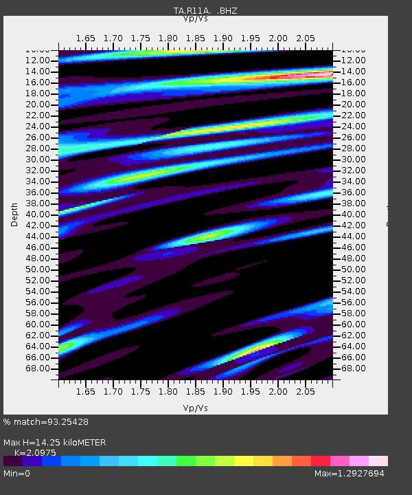
| Estimated Moho Depth: |
14.25 km |
| Estimated Crust Vp/Vs: |
2.10 |
| Assumed Crust Vp: |
6.276 km/s |
| Estimated Crust Vs: |
2.992 km/s |
| Estimated Crust Poisson's Ratio: |
0.35 |
|
| Radial Match: |
93.25428 % |
| Radial Bump: |
335 |
| Transverse Match: |
84.99147 % |
| Transverse Bump: |
400 |
| SOD ConfigId: |
401841 |
| Insert Time: |
2011-12-21 03:30:25.302 +0000 |
| GWidth: |
2.5 |
| Max Bumps: |
400 |
| Tol: |
0.001 |
|

Signal To Noise
| Channel | StoN | STA | LTA |
| TA:R11A: :BHZ:20110716T20:05:29.300004Z | 12.737142 | 6.4943134E-7 | 5.0987207E-8 |
| TA:R11A: :BHN:20110716T20:05:29.300004Z | 6.3084617 | 3.3413104E-7 | 5.2965532E-8 |
| TA:R11A: :BHE:20110716T20:05:29.300004Z | 4.150743 | 4.2218306E-7 | 1.01712644E-7 |
| Arrivals |
| Ps | 2.6 SECOND |
| PpPs | 6.6 SECOND |
| PsPs/PpSs | 9.3 SECOND |


