You are here: Home > Network List > TA - USArray Transportable Network (new EarthScope stations) Stations List
> Station MDND Maddock, ND, USA > Earthquake Result Viewer
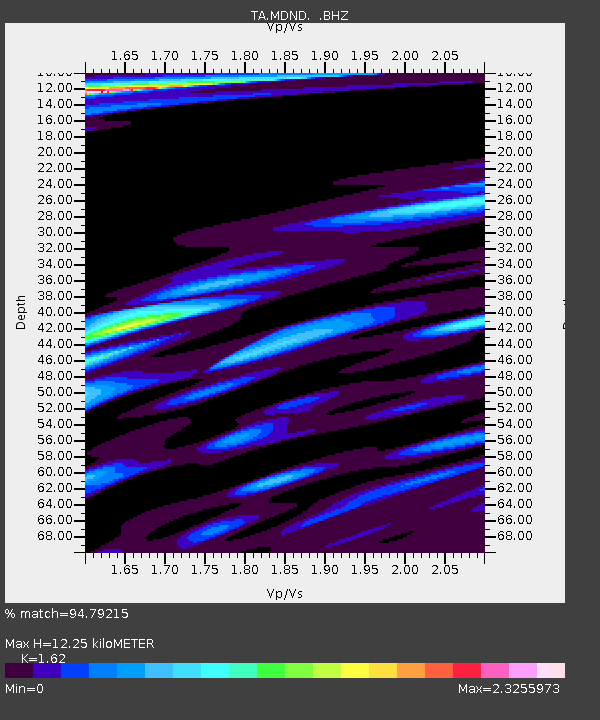
MDND Maddock, ND, USA - Earthquake Result Viewer
| Earthquake location: |
Alaska Peninsula |
| Earthquake latitude/longitude: |
54.8/-161.3 |
| Earthquake time(UTC): |
2011/07/16 (197) 19:59:12 GMT |
| Earthquake Depth: |
36 km |
| Earthquake Magnitude: |
6.3 MB, 5.9 MS, 6.2 MW, 6.1 MW |
| Earthquake Catalog/Contributor: |
WHDF/NEIC |
|
| Network: |
TA USArray Transportable Network (new EarthScope stations) |
| Station: |
MDND Maddock, ND, USA |
| Lat/Lon: |
47.85 N/99.60 W |
| Elevation: |
479 m |
|
| Distance: |
38.0 deg |
| Az: |
74.211 deg |
| Baz: |
304.162 deg |
| Ray Param: |
0.0757163 |
| Estimated Moho Depth: |
12.25 km |
| Estimated Crust Vp/Vs: |
1.62 |
| Assumed Crust Vp: |
6.53 km/s |
| Estimated Crust Vs: |
4.031 km/s |
| Estimated Crust Poisson's Ratio: |
0.19 |
|
| Radial Match: |
94.79215 % |
| Radial Bump: |
322 |
| Transverse Match: |
75.813835 % |
| Transverse Bump: |
400 |
| SOD ConfigId: |
401841 |
| Insert Time: |
2011-12-21 03:31:46.068 +0000 |
| GWidth: |
2.5 |
| Max Bumps: |
400 |
| Tol: |
0.001 |
|

Signal To Noise
| Channel | StoN | STA | LTA |
| TA:MDND: :BHZ:20110716T20:05:57.40001Z | 27.513313 | 2.9408404E-6 | 1.0688791E-7 |
| TA:MDND: :BHN:20110716T20:05:57.40001Z | 3.2562299 | 7.9718416E-7 | 2.4481815E-7 |
| TA:MDND: :BHE:20110716T20:05:57.40001Z | 4.3596816 | 1.5935765E-6 | 3.6552592E-7 |
| Arrivals |
| Ps | 1.3 SECOND |
| PpPs | 4.5 SECOND |
| PsPs/PpSs | 5.8 SECOND |


