You are here: Home > Network List > TA - USArray Transportable Network (new EarthScope stations) Stations List
> Station H25A Fruitdale, SD, USA > Earthquake Result Viewer
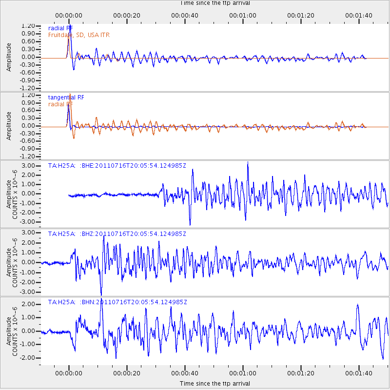
H25A Fruitdale, SD, USA - Earthquake Result Viewer
*The percent match for this event was below the threshold and hence no stack was calculated.
| Earthquake location: |
Alaska Peninsula |
| Earthquake latitude/longitude: |
54.8/-161.3 |
| Earthquake time(UTC): |
2011/07/16 (197) 19:59:12 GMT |
| Earthquake Depth: |
36 km |
| Earthquake Magnitude: |
6.3 MB, 5.9 MS, 6.2 MW, 6.1 MW |
| Earthquake Catalog/Contributor: |
WHDF/NEIC |
|
| Network: |
TA USArray Transportable Network (new EarthScope stations) |
| Station: |
H25A Fruitdale, SD, USA |
| Lat/Lon: |
44.62 N/103.60 W |
| Elevation: |
942 m |
|
| Distance: |
37.7 deg |
| Az: |
81.118 deg |
| Baz: |
306.741 deg |
| Ray Param: |
$rayparam |
*The percent match for this event was below the threshold and hence was not used in the summary stack. |
|
| Radial Match: |
88.71317 % |
| Radial Bump: |
359 |
| Transverse Match: |
99.133255 % |
| Transverse Bump: |
140 |
| SOD ConfigId: |
401841 |
| Insert Time: |
2011-12-21 03:32:47.748 +0000 |
| GWidth: |
2.5 |
| Max Bumps: |
400 |
| Tol: |
0.001 |
|
Signal To Noise
| Channel | StoN | STA | LTA |
| TA:H25A: :BHZ:20110716T20:05:54.124985Z | 10.641874 | 7.875042E-7 | 7.400051E-8 |
| TA:H25A: :BHN:20110716T20:05:54.124985Z | 9.450083 | 6.8086143E-7 | 7.20482E-8 |
| TA:H25A: :BHE:20110716T20:05:54.124985Z | 5.9244823 | 5.082217E-7 | 8.578331E-8 |
| Arrivals |
| Ps | |
| PpPs | |
| PsPs/PpSs | |


