You are here: Home > Network List > TA - USArray Transportable Network (new EarthScope stations) Stations List
> Station B30A Myrvik Farm, Edmore, ND, USA > Earthquake Result Viewer
B30A Myrvik Farm, Edmore, ND, USA - Earthquake Result Viewer
| Earthquake location: |
Alaska Peninsula |
| Earthquake latitude/longitude: |
54.8/-161.3 |
| Earthquake time(UTC): |
2011/07/16 (197) 19:59:12 GMT |
| Earthquake Depth: |
36 km |
| Earthquake Magnitude: |
6.3 MB, 5.9 MS, 6.2 MW, 6.1 MW |
| Earthquake Catalog/Contributor: |
WHDF/NEIC |
|
| Network: |
TA USArray Transportable Network (new EarthScope stations) |
| Station: |
B30A Myrvik Farm, Edmore, ND, USA |
| Lat/Lon: |
48.45 N/98.33 W |
| Elevation: |
480 m |
|
| Distance: |
38.4 deg |
| Az: |
72.632 deg |
| Baz: |
303.868 deg |
| Ray Param: |
0.07550276 |
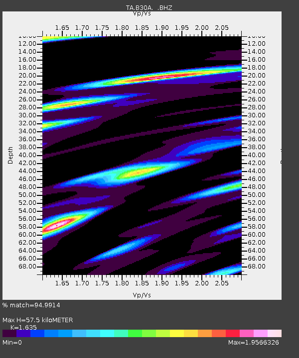
| Estimated Moho Depth: |
57.5 km |
| Estimated Crust Vp/Vs: |
1.63 |
| Assumed Crust Vp: |
6.53 km/s |
| Estimated Crust Vs: |
3.994 km/s |
| Estimated Crust Poisson's Ratio: |
0.20 |
|
| Radial Match: |
94.9914 % |
| Radial Bump: |
377 |
| Transverse Match: |
80.62329 % |
| Transverse Bump: |
400 |
| SOD ConfigId: |
401841 |
| Insert Time: |
2011-12-21 03:33:25.296 +0000 |
| GWidth: |
2.5 |
| Max Bumps: |
400 |
| Tol: |
0.001 |
|
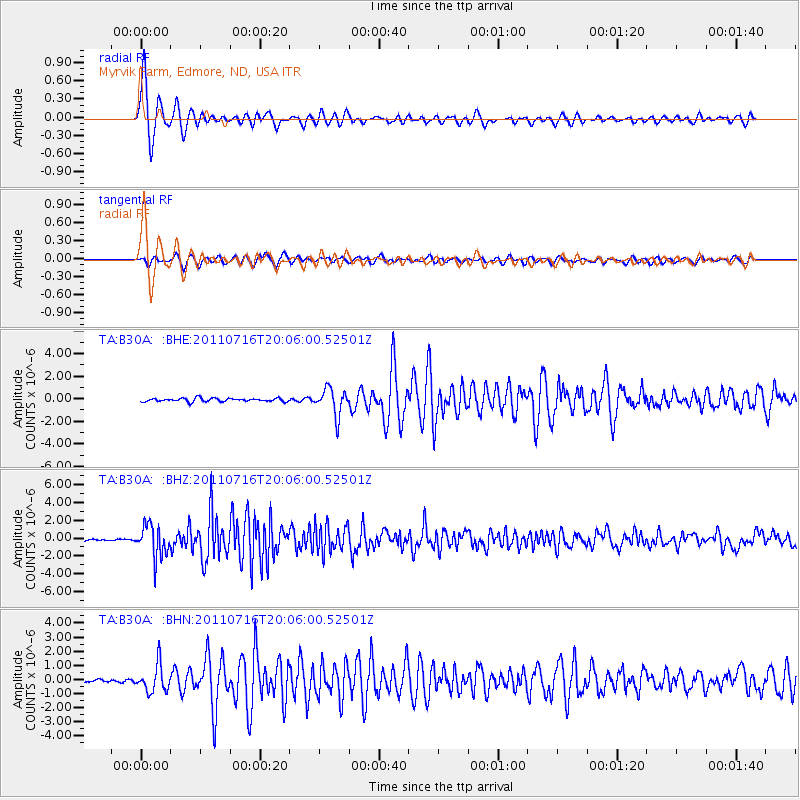
Signal To Noise
| Channel | StoN | STA | LTA |
| TA:B30A: :BHZ:20110716T20:06:00.52501Z | 22.14562 | 1.785217E-6 | 8.061265E-8 |
| TA:B30A: :BHN:20110716T20:06:00.52501Z | 4.348285 | 9.534582E-7 | 2.1927222E-7 |
| TA:B30A: :BHE:20110716T20:06:00.52501Z | 7.9603457 | 1.1660069E-6 | 1.4647692E-7 |
| Arrivals |
| Ps | 6.1 SECOND |
| PpPs | 21 SECOND |
| PsPs/PpSs | 27 SECOND |


