You are here: Home > Network List > TA - USArray Transportable Network (new EarthScope stations) Stations List
> Station O32A Brockman Farm, Red Cloud, NE, USA > Earthquake Result Viewer
O32A Brockman Farm, Red Cloud, NE, USA - Earthquake Result Viewer
| Earthquake location: |
Alaska Peninsula |
| Earthquake latitude/longitude: |
54.8/-161.3 |
| Earthquake time(UTC): |
2011/07/16 (197) 19:59:12 GMT |
| Earthquake Depth: |
36 km |
| Earthquake Magnitude: |
6.3 MB, 5.9 MS, 6.2 MW, 6.1 MW |
| Earthquake Catalog/Contributor: |
WHDF/NEIC |
|
| Network: |
TA USArray Transportable Network (new EarthScope stations) |
| Station: |
O32A Brockman Farm, Red Cloud, NE, USA |
| Lat/Lon: |
40.26 N/98.28 W |
| Elevation: |
579 m |
|
| Distance: |
43.5 deg |
| Az: |
82.499 deg |
| Baz: |
311.374 deg |
| Ray Param: |
0.07246239 |
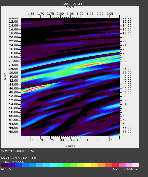
| Estimated Moho Depth: |
46.0 km |
| Estimated Crust Vp/Vs: |
1.67 |
| Assumed Crust Vp: |
6.53 km/s |
| Estimated Crust Vs: |
3.91 km/s |
| Estimated Crust Poisson's Ratio: |
0.22 |
|
| Radial Match: |
88.477196 % |
| Radial Bump: |
400 |
| Transverse Match: |
70.9014 % |
| Transverse Bump: |
400 |
| SOD ConfigId: |
401841 |
| Insert Time: |
2011-12-21 03:34:30.296 +0000 |
| GWidth: |
2.5 |
| Max Bumps: |
400 |
| Tol: |
0.001 |
|

Signal To Noise
| Channel | StoN | STA | LTA |
| TA:O32A: :BHZ:20110716T20:06:41.974991Z | 10.277118 | 8.877513E-7 | 8.6381355E-8 |
| TA:O32A: :BHN:20110716T20:06:41.974991Z | 1.5352468 | 4.410163E-7 | 2.8726083E-7 |
| TA:O32A: :BHE:20110716T20:06:41.974991Z | 2.0596492 | 3.925987E-7 | 1.9061436E-7 |
| Arrivals |
| Ps | 5.1 SECOND |
| PpPs | 17 SECOND |
| PsPs/PpSs | 23 SECOND |


